Thursday, February 23, 2017

BOTANEIATES PALACE

Cağaloğlu, Fatih - Istanbul - Turkey

GPS : 41°00'48.6"N 28°58'24.4"E / 41.013500, 28.973444

Botaneiates Palaca / Cagaloglu - Istanbul photo botaneiates_palace101.jpg

PHOTOGRAPHS ALBUM

In 1192, the byzantine emperor gave to the Genoese among other property in the city the so-called palace of Botaneiates, probably former a possession of the emperor Nikephoros Botaneiates (1078-1081) or a member of his family. The palace consisted of a number of houses and pavillons of small or middle size, and two churches arranged around several terraces on different levels, and inclosed by a wall.

The reconstruction is based on the description given by the treaty of 1192. It has been located at the remains of an early byzantine substructure in the northwest of the present Erkek Lisesi, but it is more probable that it lay in the gardens of Topkapı Sarayı somewhere to the west of the Column of the Goths.

Emperor Nikephorus Botaneiates ruled from 1078 to 1081. He (or a close relative) appears to have built a palace, as the unfortunate emperor Isaac II Angelos was obliged to give one of that name to the Genoese in the embarrassing kerfuffle leading up to the 1204 Latin invasion. As the various parties who were to make up the fourth crusade turned the screws on Constantinople, more and more money, properties and concessions were given in response to the demands of the eventual invaders.

Some of the background to the strained relations between Isaac II and the forces of the third crusade (1189 - 1192) can be found here. A treaty of 1192 leaked another driblet of power and property from the shrivelled wineskin of Constantinople into the greedy mouth of Genoa.

In the grounds of the old Istanbul High School (Istanbul Erkek Lisesi) are some Byzantine remains that the academic might of Dumbarton Oaks identified as the Palace of the Botaneiates. West of the handsome late Ottoman school building is this structure.

It corresponds to the kind of brickwork characteristic of a church of the 11th century and a few arches hint at a grandeur that is very much gone. The Byzantium 1200 site has attempted an online reconstruction of the palace but this is based only on analysis of the wording of the 1192 treaty. The site appears to have contained two churches. The other may have been built over the cistern, substantial remains of which can be found downhill from the school.

Along one of the few remaining Byzantine street frontages in Istanbul are several barred windows and doors. The window bars are so old that they have been pulled away so people can dump rubbish inside. The door to the eastern side does not appear to be locked but the weight of trash and the welding of corrosion mean that it can no longer be opened.

So you get in through the window trash chute. I couldn’t find anyone with a key to the other doors. It may be available from the school. You’ll need a rope to get to the bottom. Don’t go soon after heavy rain. Water that adds romance to Yerebatan Cistern merely allows a lot of awful things to bump against your legs and keeps you wondering what horrors lie beneath the surface.

The wonderful Nicholas Artamonoff photographed the cistern in May 1945 and four of his pictures may be found here. My pictures from March 2015 show that little has changed except, if anything, the level of rubbish is lower now. Churches of this period were often built above such cisterns. One can climb onto the roof because the building above is derelict and the resident guard dog is desperate for attention. There’s not much to see.

One final point illustrates the tentative nature of church identification in Istanbul. The Byzantium 1200 site offers the comment that the Palace of the Botaneiates was more likely to have been in the Sarayburnu area. If this is true, this leaves us with no idea of what this place once was.

LOCATION SATELLITE MAP


These scripts and photographs are registered under © Copyright 2017, respected writers and photographers from the internet. All Rights Reserved.

SATYROS MONASTERY

Küçükyalı, Maltepe - İstanbul - Turkey

GPS : 40°56'36.0"N 29°06'56.3"E / 40.943333, 29.115639

Satyros Monestry / Kucukyali - Istanbul photo satyros_monastery101.jpg

PHOTOGRAPHS ALBUM

It is claimed that the ruins of the 9th century Satyros Monastery or Bryas Place is located in the Küçükyalı Çınar district on land next to the mosque and the office of the village headman. Ioannes Grammatikos, who was sent as Byzantine envoy to Abbasid Caliph Memnun, recounted how impressed he was by the palace of the caliph to the Emperor Theophilus after his return home in 832. It is believed that the Architect Patrikios started construction of the palace in the year 832.

Architectural materials from the Satyr Temple, which was near to the palace, were used in its construction. The fate of the palace is unknown after the period of Emperor Theophilus. There is a very large cistern to the west of the ruins.

The Küçükyalı Arkeopark, a large archaeological area on the Asian side of Istanbul, hosts the only surviving Byzantine monastic complex in the city. The 9th-century complex contains gorgeous marble floors, valuable mosaics and beautiful art objects that she hopes to see in a museum someday

The remains in question represent the patriarchal monastic complex of Satyros. It is the only surviving 9th century-structure in the city and was built by Patriarch Ignatios between 866 and 877. His body was buried at the site next to a large sized church dedicated to St. Michael, a prominent figure in Byzantine history who is depicted in the mosaics inside Hagia Sophia.

The large triple-apsed church with cross-in-square plan and the large (2700 cubic metres) cistern must have belonged to the Monastery of Satyros (AD 867-877) and not the Palace of Bryas (first half of the 9th century) as had been thought.

The church was refurbished in the 12th century, with the addition of a “reliquary chapel” and opus sectile flooring in the apse of the church. Georadar and geoelectrical prospection, combined with topographical study of remains, indicates that the church and cistern were the nucleus of a much more extensive complex.

The vaulted monastery, cistern and water channels are considered rare examples of their time. The constructions when they were built could be seen from the Prince’s Islands. The French author Pargoire wrote a study on monasteries on the Marmara seashore that identified the ruins in the area as part of the Satyros Monastery, an identification later supported by Ernst Mamboury, a geometry teacher at Galatasaray High School.

In addition to identifying the site as Byzantine, the excavations have retrieved organic residue from the period that are being used to examine patterns of climate change and other aspects of the history of Istanbul. There is nothing from the Ottoman period here, not even a piece of pottery. Found beautifully decorated marble floors, golden mosaics, wonderful coins and beautiful art objects that deserve to be displayed in a museum.

Although the ancient monastery had been used in Ottoman times as a stable for sheep and possibly elephants, its identity remained obscure until excavations and research in the last 15 years identified it as the Monastery of Satyros built by Patriarch Ignatios born the son of a Byzantine emperor.

 Ignatios was castrated and exiled to the Princes Islands when rivals deposed his father. Later he became patriarch and built several monasteries on the islands and elsewhere in Constantinople. His grave is believed to lie in the Monastery of Satyros, awaiting continued excavations on the site. Visitors curious about his character can see his portrait at the Hagia Sophia in the upper galleries of the building.

LOCATION SATELLITE MAP


These scripts and photographs are registered under © Copyright 2017, respected writers and photographers from the internet. All Rights Reserved.

BATHONEA PORT RUINS

Küçükçekmece - İstanbul - Turkey

GPS : 41°02'05.8"N 28°44'03.1"E / 41.034944, 28.734194

Bathonea Port Ruins / Kucukcekmece - Istanbul photo bathonea_kcekmece101.jpg

PHOTOGRAPHS ALBUM

Hidden for a millennium, it took a 21st-century drought to reveal the ruins of a long-lost port city. Five years after archaeologists discovered its four-kilometer-long seawall on a polluted lake 20 km from Istanbul, they continue to unearth Bathonea, which is yielding a wealth of rare artifacts and architecture spanning a thousand years of the Byzantine era. Excavations this year have essentially doubled Bathonea's known size, bolstering the idea that it was a well-connected, wealthy, fully outfitted harbor city that thrived from the fourth to 11th century, when a massive earthquake leveled much of it.

Bathonea is a rare and important find because little remains in Byzantium proper (now the modern city of Istanbul) of the first few centuries of the Byzantine, or Eastern Roman, Empire. The ancient urban center has been built over too many times in its 1,600-year history to leave much behind. Located on a long-farmed peninsula on Lake Küçükçekmece, once an inlet on the Marmara Sea, Bathonea reappeared in 2007 after a drought lowered the lake's water table, exposing portions of the seawall.

It turned out to be almost half the length of the wall that once surrounded Constantinople (as Byzantium had been renamed for Constantine the Great). The wall's substantial size suggested Bathonea was a significant safe harbor for ships on their way to Constantinople beginning in the fourth century, just as the city became the seat of power for the Eastern Roman Empire.

In previous years archaeologists have unearthed some of the seawall, a multistory villa or palace, an enormous cistern, the round foundations of a Greek temple, and the toppled remains of a Byzantine church and cemetery. Nearby, stone roads crisscross each other and 1,500 years of history.

This year they discovered a large multistory building and a series of smaller rooms adjacent to the villa that artifacts indicate was a monastery with workshops for making metal, jewelry and glass that began production in the fourth century. The jewelry molds they discovered may be the first archaeological evidence for jewelry production in Constantinople, a tradition known from historical sources.

Another key find is the exceptionally preserved, two-part network of underground water channels hundreds of meters long that kept Bathonea's cistern and buildings supplied with freshwater. They also found a Hellenistic building hiding in plain sight among 19th-century structures and a road connecting it to a second-century B.C. harbor, providing more evidence of Bathonea's earliest days.

A massive earthquake in the 11th century seems to have largely destroyed Bathonea. Archaeologists continue to find toppled walls (including one that killed the three men found beneath the rubble) from all the buildings. Yet judging from the pottery found, some residents eked out a life at Bathonea as late as the 12th century.

To try to answer these questions, Aydingün and her team will focus next year's dig on the seaward tip of the peninsula, where ground-penetrating radar has detected underground anomalies that may be structures. They also hope to restart underwater exploration. In 2008 they discovered an edifice that may have been a lighthouse. Local lore holds that it is a magical minaret that rises in warning whenever nearby villagers sin too much.

Hundreds of bricks stamped Konstans, made in Constantinople starting in the fifth century, were found at Bathonea. The find is Bathonea, a substantial harbor town dating from the second century B.C. Discovered in 2007 after a drought lowered the lake’s water table, it has been yielding a trove of relics from the fourth to the sixth centuries A.D., a period that parallels Istanbul’s founding and its rise as Constantinople, a seat of power in the Eastern Roman / Byzantine and Ottoman Empires.
   
While there are some historical records of this early period, precious few physical artifacts exist. The slim offerings in the Istanbul section of the Archaeological Museums here reflect that, paling in comparison with the riches on display from Anatolia, Mesopotamia and Lebanon. So Bathonea has the potential to become a “library of Constantinople,” says the archaeologist who made the initial discovery.

After the drought exposed parts of a well-preserved sea wall nearly two and a half miles long, archaeologist team soon saw that the harbor had been equipped with docks, buildings and a jetty, probably dating to the fourth century. Other discoveries rapidly followed. In the last dig season alone, the archaeologists uncovered port walls, elaborate buildings, an enormous cistern, a Byzantine church and stone roads spanning more than 1,000 years of occupation.
   
Since then, Dr. Aydingun’s team and researchers from eight foreign universities have found a second, older port on the peninsula’s eastern side, its Greek influences suggesting that it dated to about the second century B.C.

Spelunkers explored hundreds of feet of a two-part water channel system that archaeologists discovered. The channels directed freshwater to the cistern and buildings throughout Bathonea. They showed us that such an infrastructure can only be constructed for a very big and important settlement.
       
Nearby, atop the round foundations of a Greek temple, they found the remains of a fifth- or sixth-century Byzantine church and cemetery with 20 burials, and a large stone relief of a Byzantine cross. Coins, pottery and other artifacts indicate that the church suffered damage in the devastating earthquake of 557 but was in use until 1037, when a tremor leveled it -  crushing three men whose bodies were found beneath a collapsed wall, along with a coin bearing the image of a minor emperor who ruled during the year of the quake.
   
After bushwhacking through nettle-choked underbrush a mile and a half north of the harbor, the researchers excavated a 360-by-90-foot open-air cistern or pool, as well as walls and foundations from several multistory buildings that may have been part of a villa or palace altered over many centuries.
   
Because the archaeologists are at the beginning of a multiyear dig at a site not known from historical sources, they are hesitant to draw many conclusions. Even the name Bathonea is a placeholder, inspired by two ancient references: the first-century historian Pliny the Elder’s “Natural History,” which refers to the river feeding the lake as Bathynias; and a work by a ninth-century Byzantine monk, Theophanes, who called the region Bathyasos.

The archaeologists know this much: The site was large. It sprawled across at least three square miles, and its sea wall is nearly half the length of the one that surrounded Constantinople itself. It was moderately wealthy; the region was a country retreat for the urban elite, drawn by its fertile hunting grounds and Lake Küçükçekmece itself, the freshwater body closest to the city. They built villas and palaces all around the region.

As seen in this stitched-together image, the pipes poking through the cistern wall look almost modern and just as ready to pour fresh springwater as they were 1,650 years ago.  At least 80 meters long, the cistern was entirely constructed from bricks stamped with the name of Constantine or his sons Constantine II and Konstans, which have mostly been discovered at imperial sites like Hagia Sophia.

Roman glass and high-end pottery dating as late as the 14th century were found throughout the site. Marble, including a gorgeous milky-blue variety, lined the walls and floors of the church and at least one of the buildings.
     
Also discovered were hundreds of bricks stamped “Konstans,” which were produced in Constantinople beginning in the fifth century and had mostly been discovered at imperial sites like Hagia Sophia, the sixth-century architectural marvel and primary cathedral of the Byzantine Empire for almost 900 years, and nearby Rhegion, a fifth-century compound on a hill across the lake from Bathonea, overlooking the Marmara Sea.
   
Bathonea was also well connected. Some pottery was made as far away as Palestine and Syria, typical of places with access to foreign goods. It had wide stone roads, the earliest dating to the Roman era. But its relationship to Constantinople is still unclear. “I like the idea of Bathonea as a satellite port of a major city,” said Bradley A. Ault, a classical archaeologist with the University at Buffalo who has studied ancient port cities in Greece and Cyprus. “It falls in line with Athens and Piraeus, Rome and Ostia.”
   
If that is the case, the port may have served as a safe harbor on protected waters outside the city walls for both commercial ships and the imperial naval fleet. “In the fifth century, they had a major fleet around Constantinople,” said Robert Ousterhout, a Byzantine scholar at the University of Pennsylvania. “They had ports around the Golden Horn and the Marmara.” Now 13 to 65 feet deep, Lake Küçükçekmece would have been a deep bay navigable by ships of all sizes, Dr. Aydıngün said. Sonar has revealed what may be six Byzantine iron anchors buried in the sand just offshore, and nails commonly used in shipbuilding were unearthed at the site.
       
In recent years, Istanbul has been the scene of several stunning discoveries during salvage archaeology digs, most notably at the Yenikapı transit project, which unearthed a remarkable array of shipwrecks. No shipwrecks have been found at Bathonea; nor are they likely to be anytime soon, said Mr. Oniz, the underwater archaeologist. The lake is so polluted by industrial runoff that diving in it is dangerous, he said. A new water-treatment facility may make exploration possible within a few years.
     
The Bathonea archaeologists also hope to uncover more artifacts dating to the earliest days of civilization. In 2007, Dr. Aydıngün and Emre Güldoğan of Istanbul University found 9,000-year-old flint tools at the site that could be evidence of the earliest pre-pottery farming settlement in Europe. Bathonea’s role - and its real name - can be determined only through further study, Dr. Aydıngün said.
   
Ground-penetrating radar has indicated that extensive structures remain beneath the soil. And as all of their efforts have been focused on the waterfront, the archaeologists have yet to investigate the patches of trees and brush farther inland that farmers have long avoided because their plows cannot cut through them.
   
It doesn't look like much, but archaeologists were excited to find this plaster-coated building hiding in plain sight because it provides more evidence of Bathonea's beginnings. Adjoined to crumbling late-Ottoman buildings, obscured by trees and brush, its walls had been slathered in a deceptive layer of plaster. This summer the plaster was chipped away to reveal wide, rectangular blocks that are typical of Hellenistic buildings from the second century B.C.

It's located on a newly unearthed road that leads to the harbor of the same era. They also found Hellenistic pottery shards in the rubble near the wall. The team speculates it may have been a warehouse. Adjacent to the palace archaeologists unearthed one large building and a series of smaller ones that appear to be parts of a complex dating back to the fourth century, which included the palace, a monastery and a series of workshops for making metal, glass and jewelry.
.
The finds include smelting waste and rare jewelry molds. "From written sources it's known that Constantinopolis had jewelry workshops since the Roman and Byzantine times," archaeologists says. "Our findings may be the first-ever proof. But it is too early to claim it with some confidence. We are still checking with metalwork historians."

The remains of a well-appointed villa continue to yield evidence of its residents' wealth. The nine-meter walls held statue nooks and ornate wall mosaics; thousands of dirt-encrusted tesserae were found this year. Milky blue marble lined the floors and an extensive water system channeled freshwater throughout. The small graves likely once held children.

This aerial shows about a third of the excavated site - a section archaeologists call the "little harbor" after the second-century B.C. pier shown at left. At right are newly uncovered crisscrossing roads spanning 1,500 years, the round foundations of a Greek temple, a fifth-century Byzantine church and cemetery as well as an Ottoman-era building. Hidden by trees is a newly spotted Hellenistic edifice, positioned just up the road from the harbor.

LOCATION SATELLITE MAP


These scripts and photographs are registered under © Copyright 2017, respected writers and photographers from the internet. All Rights Reserved. 

Tuesday, February 21, 2017

HIPPODROME SPHENDONE

Sultanahmet, Fatih - İstanbul - Turkey

GPS : 41°00'14.1"N 28°58'26.2"E / 41.003917, 28.973944

Hippodrome Sphendone / Sultanahmet - Istanbul photo hippodrome_sphendone101.jpg

PHOTOGRAPHS ALBUM

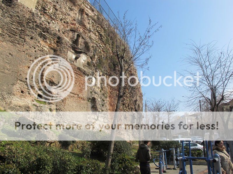
At the southern end of the Hippodrome, where the land begins to slope down to the sea, a series of massive vaults were constructed to serve as a retaining wall for the Sphendone, that curved section of the track where it turns back to the starting gates. In 1927, a British expedition led by Stanley Casson spent four months excavating and studying the Hippodrome, especially the foundation of the Sphendone.

Behind the twenty-five supporting arches (some still visible above) were found a corresponding number of concentric chambers opening out onto a main corridor. After a devastating earthquake in AD 551 (which also collapsed the dome of Hagia Sophia), these arches were bricked up and a series of buttresses added. Sometime later, the chambers themselves were closed off and converted to a cistern.

Around the entire Hippodrome was an arcade of columns, as can be seen in the drawings below. The itinerary of an anonymous Russian pilgrim records that thirty columns still were standing early in the fifteenth century. When Petrus Gyllius (the Latinized version of Pierre Gilles) visited in 1544-1547 as a deputy of François I, seventeen remained, all of them "supported by arched foundations that lie level with the plain of the Hippodrome but rise above the ground to a height of fifty feet". But, he says, they soon were removed by Süleyman (the Magnificent) to build a hospital.

"I was concerned to see them thus demolished, not so much for the use they were intended but because some of them were squared out for paving a bath." The Corinthian capitals of white marble, "made after the most exact plans of ancient architecture," were reshaped to cover a bake house, and the pedestals and entablature to build a wall. A section of column found by Casson in the Hippodrome also is the same size and type as those in the courtyard of the Sultan Ahmet Mosque (right).

Backed against this arcade of columns were tiers of seats, which the crusader Robert de Clari counted as thirty or forty rows. They, too, seem to have been used as paving stones for the courtyard of the mosque. And some, "which had survived until only a few years ago," were taken by Ibrahim Pasha, Süleyman's grand vizier, to construct his palace across from the obelisk of Theodosius.

Originally, the tiers had been built of wood and repeatedly were set ablaze during factional violence in AD 491, 498, and 507 (when an arch also collapsed). The last conflagration occurred during the Nika riot in AD 532, when the factions again set fire to the tiers, burning part of the colonnade. No other fires are reported, and it is presumed that Justinian I rebuilt the seats in marble. Although Gyllius comments on the fine view from the top seats, the Sphendone more often was the scene of public executions and so was especially prized by the populace for the political theater it offered.

Under Valentinian I, for example, the chief eunuch was burned alive at the Sphendone during the chariot races, and a prefect being questioned by the senate was tripped up and fell at the turning post, where he was dragged away by the mob (Chronicon Paschal, 369, 465). Others were mutilated, decapitated, and executed. The last was an attendant to a rival of Andronicus I Comnenus, who had the lamentable young man repeatedly thrust by long poles into a fire made hotter still by brush wood and naphtha.

Andronicus, himself, perished even more miserably in the Hippodrome, being butchered after every indignity while being suspended by his feet near the she-wolf on the spina (349-352). Casson established that the Sphendone was a semicircle, and the diameter of the Hippodrome to be 117.5 meters (385.5 feet) and its length 480 meters (almost 1575 feet). Originally, the track was 4.5 meters (almost 15 feet) below the present surface level, the deposit of earth and debris having accumulated during the construction of the Sultan Ahmet Mosque.

Surprisingly, and in spite of Robert de Clari's remark that "Lengthwise of this space ran a wall, full fifteen feet high and ten feet wide," Casson found no evidence of a spina along the axis and concluded that the monuments, themselves, served the purpose, possibly joined by wooden barriers. Too, the pedestal of the column of Porphyrogenitus was discovered to have been fitted to serve as a fountain, with a spout on each of its four sides. A similar water conduit was found to run beneath the obelisk of Theodosius.

The Serpent Column rests on a reused column capital which, in turn, sits on two water conduits sunk into the original clay bedding of the Hippodrome and also served as a fountain. There even was a tradition that wine, milk, and water poured from the mouths of the serpents. Although Casson suggests that the column originally might have been located elsewhere in the Hippodrome and moved to its present location only at the close of the Byzantine period, it more likely always has been on the spina.

The hippodrome was one of five types of places of public entertainment in cities of Antiquity. The odeon (recital hall) was comparatively small in size and capacity, and was the only one roofed over.

The others, open to the sky, differed in functions: the theater (theatron), semi-circular in shape, intended for various stage presentations; the amphitheater (amphitheatrum or "double theater"), elliptical in shape, developed by the Romans for gladiatorial and animal spectacles; the stadium (stadion), a hair-pin rectangle in shape (with one end curved), intended for foot-racing; and the hippodrome (Roman circus), of essentially the same shape, but larger, for horseback or chariot races. All forms had seating of tiered stone benches built over internal vaulting. Their respective functions could sometimes overlap.

Constantinople's Hippodrome, imitating Rome's archetypal Circus Maximus, was among the largest. In its Byzantine form, it measured somewhere between 450 and 480 meters in length, 117 meters in external width and about 80 meters in internal width. Its estimated seating capacity was 100,000. The southwestern semicircular end (the sphendone, from "sling") was topped by a colonnade. At the straight (northeast) end, there were twelve gates (carceres; kankella, thyrai) that could be opened mechanically at the same moment.

On a tower over these gates stood the famous four bronze horses carried off by the Venetians after 1204 and placed over the portal of the San Marco Basilica. At about the midpoint on the eastern side, above the seats, was the imperial box (kathisma), which connected to the Great Palace complex behind it. Down the center of the arena ran the barrier wall, or spina (euripos), around which the races were run in counterclockwise course.

At each end of the spina was a turning-post or meta (kampter), and along this barrier were mounted various ornaments, as well as frames each holding the pivotable metal figures of seven dolphins, which could be rotated in turn to mark the running of the seven laps in each race. These races, held at regular points each year, were run by charioteers, each in a quadriga, a two-wheeled car pulled by a team of four horses. Between races, acrobats, dancers, and musicians offered entertainment.

Structurally, the Hippodrome predates Constantinople itself. The ancient Greek city of Byzantium, destroyed by Septimius Severus (193-211) for its disloyalty, was rebuilt by him in 203. His gigantic supporting masonry can still be seen beneath the Hippodrome's sphendone on its sloping south hill. The Severan Hippodrome was left unfinished. It was expanded and completed in the context of the transformation by Constantine the Great (324-337) of old Byzantium into his new capital of Constantinople, finished in 330.

Constantine was followed by his successors in adorning the Hippodrome's spina with sculptural treasures from around the empire, imitating the Circus Maximus.6 There were notable bronze statues, and in the center was placed at some point the great bronze Serpent Column that had been dedicated at Delphi in honor of the Greek victory over the Persians in 479 B.C. The original meanings of these monuments were not always understood fully: the Serpent Column itself was for a while fitted out as a fountain.

To its north, meanwhile, an Egyptian obelisk had been placed. It was originally one of a pair set up near Thebes by Pharaoh Thutmose III in the 5th c. B.C. Its sister was mounted in the Circus Maximus in Rome, while this one was brought to Constantinople. It was shattered in transit, but in 390 the surviving upper third was set up in honor of Emperor Theodosius I (379-395), atop a base carved with triumphal scenes showing the Emperor and his sons, plus scenes of the obelisk's erection.

At the other side of the Serpent Column was constructed, probably also in the fourth century, a built-up masonry obelisk. In the sixteenth century a French traveller gave named it the "Colossus" because of an inscription - comparing it to the ancient Colossus of Rhodes - set on it by Emperor Constantine VII Porphyrogenitos (913-959), to whom this obelisk has also been erroneously attributed.

In the transformation of the city from Byzantium to his new capital, Constantine focused on the adornment of the monumental core of the city, first by finishing the Severan projects. The monumental development that included the emboloi, the Tetrastoon, the Basilica, the Baths of Zeuxippos and the Hippodrome became the cornerstone of the Constantinian plan. The Constantinian manipulations of the extant Severan buildings created a monumental set of interrelated yet independent public spaces that responded to and defined public urban life.

By concentrating five major imperial foundations (the Augustaion, the Basilica, the Hippodrome, the Great Palace and the Baths of Zeuxippos) in a relatively confined area, Constantine sought to give a monumental expression of the romanitas of the urban character of the city: the overarching magnificence of Rome, its empire and its institutions. The Hippodrome and its associated palace was the manifestation of a singularly Roman mentality; it was a combination evident in the Tetrarchic capitals of the Roman world that derived ultimately from the relationship between the Circus Maximus and the imperial residence at Rome.

The image of romanitas conjured by the city’s institutions and monuments was at once general and specific. On the one hand, places as the Hippodrome and the Zeuxippos created a sense of participation in the Roman imperial experience. On the other hand, the specific conjunction of Hippodrome and Palace created a more specifically Roman link that bound Constantinople directly and intimately to the city of Rome, transforming it into the New Rome.

In ancient cities, the theaters were places of lively public assembly as well as entertainment. As proto-Byzantine Constantinople took shape, it developed none of the old open-air theaters, so the Hippodrome became the city's largest place of regular public assembly, as part of an integrated complex. To its northeast lay the great square of the Augustaion, around which stood major public and governmental buildings. Beyond that was the Patriarchate and the Great Church of Hagia Sophia, site of the Empire's spiritual ceremonial.

While the adjacent Great Palace housed court ceremonial, the Hippodrome was the place for political ceremonial. Here, and only here, the Emperor faced the mass of urban populace during regular festivities. Here new Emperors were presented, important executions carried out (e.g., of the general Narses by Emperor Phokas in 603) and celebrations were held (e.g., the triumph the general Belisarius under Justinian in 534).

It was an essential point for triumphal imperial ideology since it enabled the association of racing games with the imperial triumphs; this theme occurs frequently in the imperial iconography and was manifested in the Obelisc of Theodosios I, on the base of which the scene with the emperor presiding the games is juxtaposed with scenes of imperial triumph over the barbarians.

Popular acclamations in the Hippodrome extoled imperial omnipotence as a ritual, in which the main actor was the populace and which remained lively even at a later era, as shown by the Book of Ceremonies. Moreover, the racing operations generated the only institutions allowing some active popular participation. These were the famous demes, the circus factions. Transplanted from Rome to Constantinople (and matched in other cities) were the four fan-clubs, identified by colors, that supported the professional chariot racers, often widely acclaimed celebrities.

The two minor factions, the Whites (Leukoi) and the Reds (Rousioi) were overshadowed and virtually subsumed by the two major ones the Blues (Venetoi) and the Greens (Prasinoi). Each faction (factio; meros, demos) had reserved seats on the western side of the Hippodrome, opposite the kathisma and on either side of the finish-line, plus club-houses and facilities in the vicinity.

As the demes (especially the Greens and the Blues) grew in importance and developed their characteristic features as kinds of political parties, the Hippodrome became a place where the populace ventilated its opinion and staged politically charged acclamations, assuming opposing identities in court partisanship, in social-class ties, and in the highly explosive religious controversies of the day. In order to secure the popular support they needed, emperors often found themselves driven to favour one or other of the demes, whose intervention more than once proved crucial for imperial politics.

Their unruliness reached a peak in January 532 when they temporarily joined forces in the so-called Nika Riots. For nineteen days they defied the Emperor Justinian (527-565), raged destructively through the city, and tried to dethrone him. The disturbances were suppressed only when some 30,000 rioters were caught in the Hippodrome and massacred.

Briefly curtailed, the factional disturbances recurred in the seventh century, but the organizations were reduced to increasingly ceremonial functions by the eighth century, their titular leaders serving tame ritual roles. In fact, the factions' supposed status as substitute "political parties" in their heyday has been exaggerated: their actual members were never more than a fraction of the populace, and, despite a few neighborhood functions, they were little more that rowdy sports clubs.

If the factions were diminished, the popular taste for chariot racing was not reduced, despite long opposition from the Church. As the sport waned and disappeared in the Empire's remaining cities, it persisted as a popular distraction in the capital until final disruption by the Fourth Crusade (1202-04). Visitors in the twelfth century still reported the spectacles offered there. Nevertheless, competition to the old sport came from alternative entertainments, such as Western-style tournaments, particularly favored by the Latin-admiring Emperor Manuel I (1143-1180).

Grimmer function was served when the urban mob presided over the savage torture and execution of deposed Emperor Andronikos I (1183-1185). Already decrepit structurally, the Hippodrome began to fall into decay during the Latin occupation (1204-61), its treasures and decorations looted or destroyed by the Crusaders. In Byzantium's two final centuries the Hippodrome became a ruin, though still used occasionally for equestrian jousts.

When the Ottoman Turks took the city in 1453, they left the site open, using it as an exercise area called the Atmeydanı (the Field of Horses). But the sphendone colonnade was pulled down in 1550, while the old seating structures were gradually encroached upon and cannibalized by new Turkish buildings (e.g., Ibrahim Pasha's Palace in the sixteenth century, Sultan Ahmet I's "Blue Mosque" in the seventeenth).

In 1700 some rowdy members of a Polish diplomatic delegation decapitated the Serpent Column, carrying off its top; though the upper head of one of the three serpents has survived in the Archaeological Museum of Istambul. In 1890 the French designer Bouvard began re-designing a reduced park within the old Hippodrome space.

This design was completed after a decade at the northeast corner with the elaborate fountain donated to Sultan Abdülhamit II by Kaiser Wilhelm II in honor of his visit to the city in 1895. Some scattered excavations around the area have revealed small traces of the Hippodrome and its surroundings. But this park, an undeniably lovely public place, still incorporates at its center the two obelisks and the trunk of the Serpent Column.

LOCATION SATELLITE MAP


These scripts and photographs are registered under © Copyright 2017, respected writers and photographers from the internet. All Rights Reserved.

İNCEĞİZ CAVE MONASTERY

İnceğiz, Çatalca -  - İstanbul - Turkey

GPS : 41°10'54.2"N 28°24'14.6"E / 41.181722, 28.404056

Incegiz Cave Monastery / Catalca - Istanbul photo incegiz_cave101.jpg

PHOTOGRAPHS ALBUM

The Cave Monastery is in the neighborhood of İnceğiz village nearly to the Karasu valley, 9 km to the northwest of Çatalca. There are three places on the first floor of monastery. Monastery has four storeys within the rock. The church is on the second floor. There are three places on the third floor which two of them are longer than the other. On the fourth floor there is a place of residence measuring 5 x 5 m and a chapel. The third group monastery is two floors and the longest cave of the 4 caves on the ground floor is 11 m in length and 7 m in width. The church on the second floor is at 7 m in length and 4,5 m in width. The cross planned naos is covered by a dome which is 2,6 m diameter.

The man-made, multi-story Byzantine monastery caves and rock-cut churches in the deep valley formed by the Karasu Stream have been known by the scientific community since the 1950’s. These caves are situated near the Inceğiz village, 9 km NW of Çatalca, the most NW district of Istanbul. Thanks to their geological texture, the limestone formations in this area provided structures that can be easily hewn and comfortably used by humans.

As Dirimtekin points out, the monastery-cave and the rock-cut church system had been used from the 4th century until the end of the 12th century A.D.. However, in 1992 it became clear that the area had been settled since much earlier periods thanks to the rescue excavations of the Istanbul Archaeological Museum. The directorate of Istanbul Archaeological Museum carried out excavations between 1992 and 1995 to urgently rescue the ancient tombs that had been unearthed by illicit diggers in the area called Maltepe.

This is a plateau stretching in N-S direction at the top of the formation that hosts the rock-cut cave system of Inceğiz. These fieldworks identified a residential area, a necropolis, an ancient road, waterways and an ancient water source that are dated between the 3rd century B.C. and the 5th century A.D.. Hence, the rescue work ascertained that the earliest habitation in the area started at the hilltop long before the beginning of activity in the Inceğiz Caves down on the hillside.

Consequently, the locality of Maltepe was evidenced to have hosted a Thracian village or a small town that had intense trade contacts with Byzantion and Perinthos, both having a similar Aphrodite cult. According to Pasinli, the dwellers of this ancient village might have started using the cave shrines down on the hillside after the 4th century A.D., following the adoption of Christianity. These excavations, however, were confined only to the S sector of the plateau and did not expand towards NW.

Having considered that the region had not been investigated for nearly twenty years, the scientific committee of the Istanbul Prehistoric Research Project decided that the area should be re-surveyed. The aim of this research was to clarify if it was inhabited in earlier periods than those so far identified. In new field surveys, two deep, well-like shafts were encountered in the Maltepe area, which have not been reported in the museum excavations. The reports of the museum fieldwork only spared a few sentences to remark the presence of a water canal discovered in 1994.

It has been stated that the canal could lead to potential cisterns, as it continued towards the NW tip of the plateau, where the remains of a settlement had already been identified (Pasinli et al., 1996). Accordingly, we tried to understand whether the two new shafts were cisterns or structures serving a different function. In consequence, it has been decided to carry out the detailed investigation of the structures, whose primary examination had been performed by archaeologist Haldun Aydıngün from the scientific committee of the research project.

However, specialist researchers from speleology were required for a more comprehensive exploration of such structures. By this necessity, members of Anatolian Speleological Society (ASPEG) were invited for assistance. Following the survey and investigations of the speleology team, sufficient evidence became available for our scientific committee to define and name these structures as the Thracian Cult Pit and the Two Chamber Byzantine Cistern.

The entrance of this Thracian Cult Pit was observed to be a precise square of 230 x 230 cm dimensions, clearly indicating that the structure was man-made. Besides, each corner of this square were precisely pointing towards one cardinal direction, manifesting that the digging of this pit was not a haphazard act but a careful and well-planned undertaking from the beginning. In our investigation it became clear that a pyramidal structure with a cut-off top was created by gradually widening the pit towards the bottom.

The bedrock, into which this structure was dug, is a limestone formation of Eocen age, which is designated by geologists as the Çatalca Formation. This pyramidal pit, the counterpart of which is known in Bulgaria, is nearly 8 m deep. The bottom of the pit is covered by a dense deposit of earth that is 2-3 m thick. It was due to this deposit that we were not able to determine if the structure has other compartments. A part of this earth deposit was found scattered haphazardly by the entrance of the pit, which indicates activity of illicit diggers.

A pile of archaeological finds, which had apparently been recovered by these people from the earth deposit, was found right at the pit’s entrance. The pile contains ceramic sherds dated to the timespan between the 3rd millennium and the 1st century B.C. The earliest sherds are of a hand-made, dark-colored, polished type with inverted rims, which is well known from the major Bronze Age center of Troy I and dated to the Early Bronze Age I period (early 3rd millennium B.C.).

The group of sherds that comes next in the line of chronology belongs to the wheel-made, grey ware tradition of early 2nd millennium NW Anatolia, which is designated in recent years as the “Anatolian Grey Ware”. A single well-slipped and quite lustrous sherd resembles the Grey Ware of the Greek Mainland from the same period. The sherds of Anatolian Grey Ware are predominantly body pieces and long handles. Besides these types, hand-made, thumb-impressed, banded sherds and applique plaques of the socalled Barbarian Ware were recovered.

The Barbarian Ware is regarded an especially significant type of pottery as it is commonly considered as trace of Thracian peoples, who migrated into Anatolia around 1200 B.C. The recovery of the first examples of this pottery in Level VIIb1 settlement of Troy lead to the presumption that peoples of Thracian / Phrygian origin must have crossed the Dardanelles in their migration into the interior of Anatolia.

However, ancient authors wrote that these Balkan peoples moved into Anatolia around this time along two distinct routes, one across the Dardanelles, and other across the Bosphorus. While the evidence for the former route is progressively gaining strength through excavations at Troy and Kilisetepe in Gelibolu, the evidence for the latter route was almost nonexistent until recently.

The only example of the Barbarian Ware from around Istanbul was a small and somewhat neglected sherd found at the construction site of an extension to the Istanbul Archaeological Museum. The occurrence of the Barbarian Ware in significant quantities in our fieldwork in Çatalca enabled us to present these finds to the scientific community as the first evidence for the movement of Thracians / Phrygians across the Bosphorus. Large quantities of burnt animal bones (dog, sheep and horse), and a few burnt human bones were also attested in the thick soil deposit inside the pit.

This evidence lead to the presumption that following the cremation of the deceased, sacrificial rituals were practiced by the pit, which involved deposition of animal bones and broken pottery as offerings. Also to note is the recovery of iron slags and ores inside and around the pit, which demonstrated that people of the area knew how to work iron. As a parallel event, a small iron mine was also discovered by our research team on a sloping hill near the Çakıl Village, not far from Inceğiz.

Finally, there are the megalithic monuments, the stone blocks of which were found scattered in this area. Based on these pieces of evidence, the presence of Thracian / Phrygian peoples in this region now became more visible than before.

Numerous pieces of lekythoi, skyphoi, kantharoi, megarian bowls and amphorae were also found scattered by illicit diggers, which demonstrate that the pit was also used after the Iron Age, during the Hellenistic and Roman periods. These pieces belong to high quality and apparently expensive vessels for their time. The evidence indicates that the pit attracted local people for several millennia to be used for cult purposes.

This ceremonial significance should be the result of spiritual meanings attributed to its location and geological features. Two Chamber Byzantine Cistern The second underground structure in the Maltepe area is a two-chambered cistern system with two entrances. The larger entrance is an 8 m deep shaft with a regular rectangular cross-section of 150x115 cm dimensions. The two walls of the shaft that extend in NE-SW direction contain small niches placed at intervals, which served as steps to facilitate climbing down and up.

The second entrance is situated 17.5 m away from the first and has a regular rectangular cross-section of 120x70 cm. Just like the main entrance shaft, the second shaft was also dug vertically from above and likewise provided with small niches on opposing walls. As this second shaft is filled with branches and rocks thrown in from the outside, it could not have been entered during our research.

The cistern is accessible from the bottom of the larger shaft and consists of two separate chambers aligned in NW-SE direction. The roofs of both chambers were vaulted with a gentle curvature and very neatly plastered. A narrow, gently sloping tunnel connects the upper part of the SE chamber with the lower sector of the second entrance shaft. This connecting tunnel should have been dug in order to transfer the surface water into the cistern. A dike located at the joint of the tunnel and the chamber was possibly built to prevent the insertion of alluvium into the cistern and keep it inside the tunnel.

Thereby, the cleaning of the accumulated silt became possible as it could be reached via the smaller shaft, even when the chamber was full of water. It is generally known that the access shafts of Byzantine cisterns were closed by means of a lid system so that the collected water could remain clean. In our investigations, we could not attest either inside or outside the cistern any remains of stone, metal or brick that could belong to such a system. Taken the 1.5 x 1.15 m dimensions of the shaft into consideration, one can imagine that it could only be closed by a wooden lid.

As this cistern had been continuously disturbed by illicit diggers for many years, a dump of excavation earth has accumulated, from which only a small number of ceramic sherds were recovered. These pieces predominantly belong to the Early and Middle Byzantine periods. We think that this cistern may have been constructed to supply water to the Monastery Caves that are situated at a lower altitude on the slope of the same geological formation, into which the cistern was dug.

It was determined that these caves had been inhabited for a long time starting from the Early Byzantine period, which synchronizes them with the cistern. The construction technique of the shafts, as well as the niches in them have their exact counterparts in the Early Byzantine Manazan Caves near Taşkale in Karaman, which provides one further criterion for the proposed date of the structure. Shaft systems of the same type are also attested in Cappadocia. The cistern should also have been associated with the water canal identified in the rescue excavations of the museum.

When we visited the site in August 2012, we witnessed that illicit diggers had entered and disturbed the cistern. They apparently discovered a shallow pit in bedrock on the E side of the larger entrance shaft and dug into it to a depth of 17.5 m. They eventually accessed the smaller chamber through a horizontal tunnel, disturbing the original structure. The shallow pit, where these people started digging, is well dressed on its S and W sides, and could be an unfinished shaft of the cistern. Unfortunately, both chambers of the cistern are partially filled with rubble excavated in these illegal activities.

Recent discoveries by the Istanbul Prehistoric Research Project near the Inceğiz Village of Çatalca district prove that the area was used for cult and domestic purposes much earlier than previously thought. When we consider the evidence from the two new underground structures together with earlier research at rock-cut Byzantine shrines, it is ascertained that the habitation of the area extends from the beginning of the 3rd millennium B.C. until the end of the 12th century A.D.

This is not a surprising result given the soft limestone formations that are easy to cut, the fertile soil that is suitable for agriculture, the temperate climate of the region, and the somewhat secluded and protected character of the Karasu valley system. However, if more systematic and comprehensive excavations will be carried out, it seems possible that the history of the region can be extended even into earlier prehistory.

LOCATION SATELLITE MAP


These scripts and photographs are registered under © Copyright 2017, respected writers and photographers from the internet. All Rights Reserved.

PANAGIA HODEGETRIA AYAZMASI

Gülhane Park, Fatih - Istanbul - Turkey

GPS : 41°00'48.7"N 28°58'54.6"E / 41.013528, 28.981833

The Hodegon Monastery (also Monastery of the Panaghia Hodegetria or Monastery of the Hodegoi) in Constantinople was allegedly founded by Saint Pulcheria (399-453), a daughter of Emperor Arcadius.

Tradition states that the monastery held the Icon of the Hodegetria, believed to have been painted by Saint Luke. When the icon was sent to Pulcheria, she took a vow of chastity. The name of the icon, Panagia "Hodegetria" ("She who shows the Way"), is given through the legend which tells that nearby the church of the monastery was a source where the blind and all who suffered eye disorders came to be healed, since the Holy Virgin would have appeared to two blind people and guided them here where she restored their vision.

The sanctuary was rebuilt by Emperor Michael III (842-867) but only a few ruins are visible near Gülhane Park. The most venerated icon of the Hodegetria type, regarded as the original, was displayed in the Monastery of the Panaghia Hodegetria in Constantinople, which was built specially to contain it.

Unlike most later copies it showed the Theotokos standing full-length. It was said to have been brought back from the Holy Land by Eudocia, the Empress of Theodosius II (408-450), and to have been painted by Saint Luke. The icon was double-sided, with a crucifixion on the other side, and was "perhaps the most prominent cult object in Byzantium".

There are a number of images showing the icon in its shrine and in the course of being displayed publicly, which happened every Tuesday, and was one of the great sights of Constantinople for visitors.

It was moved to the monastery of the Pantocrator, the base of the Venetian see, from 1204 to 1261, during the period of Frankish rule, and since none of the illustrations of the shrine at the Hodegetria monastery predate this interlude, the shrine may have been created after its return.

The original icon has probably now been lost, although various traditions claim that it was carried to Russia or Italy. There are a great number of copies of the image, including many of the most venerated of Russian icons, which have themselves acquired their own status and tradition of copying.

LOCATION SATELLITE MAP


These scripts and photographs are registered under © Copyright 2017, respected writers and photographers from the internet. All Rights Reserved. 

Monday, February 20, 2017

HAGIOS POLYEUKTOS CHURCH

Saraçhane, Fatih - İstanbul - Turkey

GPS : 41°00'51.6"N 28°57'10.7"E / 41.014333, 28.952972

Hagios Polyeuktos Church / Saraçhane - Istanbul photo hagiospolieuktos101.jpg

PHOTOGRAPHS ALBUM

The architectural pieces that have been exhibited in the park on the left of the Saraçhane Street belong to Hagios Polyeuktos Church, which was built between 524 and 527 AD by Anicia Juliana, a niece to Emperor Valentinianus III. In addition, it is known that the church was the earliest basilica to have a dome. The church (measuring 52 x 58 m) was constructed with marble from Marmara Island.

The Church of St. Polyeuctus (Greek: Hagios Polyeuktos) was an ancient Byzantine church in Constantinople (now Istanbul, Turkey) built by the noblewoman Anicia Juliana and dedicated to Saint Polyeuctus. Intended as an assertion of Juliana's own imperial lineage, it was a lavishly decorated building, and the largest church of the city before the construction of the Hagia Sophia. It introduced the large-scale use of Sassanid Persian decorative elements, and may have inaugurated the new architectural type of domed basilica, perfected in the later Hagia Sophia.

Little is known of the church's history after its construction. The building survived until the 11th century, after which it fell into decay, while several architectural elements were removed and reused in Constantinople and other cities. After being built over in the Ottoman period, the site of the church was rediscovered during excavations in the 1960s. The area, directly opposite the Istanbul Metropolitan Municipality City Hall, is now a preserved archaeological site open to visitors, although the sculptures have been removed to the Istanbul Archaeological Museum.

The church was commissioned by the noblewoman Anicia Juliana, descendant of several Western emperors, and was constructed between 524 and 527, during the reign of Justin I (r. 518-527). It was meant to replace an earlier church, built by Eudocia, wife of Theodosius II and Juliana's great-grandmother, to enshrine the relic skull of Saint Polyeuctus. The new church was thought to have been the largest in Constantinople before the building of the Hagia Sophia by Justin's nephew and heir, Justinian I (r. 527-565).

In a laudatory 76-line epigram inscribed on the walls of the church and preserved in its entirety (Anthologia Graeca, I.10), Juliana compares herself to past emperors Constantine I and Theodosius II as a monumental builder, and claims to have surpassed Solomon's Temple, on whose proportions the new church was allegedly based. The building constituted thereby a direct challenge to the prestige and authority of the low-born reigning dynasty, and it may have been one of the reasons for the massive scale of Justinian's reconstruction of the Hagia Sophia a few years later.

In light of this rivalry, it is perhaps no coincidence that Justinian too, when he beheld the completed Hagia Sophia, is said to have cried out: "Solomon, I have surpassed thee". The importance of the Solomonic allusions is however questioned by some scholars, who see the church more as a statement of the imperial prestige of the Old Roman aristocracy, from which Juliana descended, and of Chalcedonian orthodoxy, which she had championed during the reign of the Monophysite emperor Anastasius I (r. 491-518).

A further aspect of the antagonism with Justinian however is evidenced by a tale recorded by Gregory of Tours: shortly after his accession, Justinian called upon the aged Juliana to contribute a part of her large fortune to the state treasury. After stalling for time, she had her gold melted down and fashioned into plates, with which she adorned the interior of the roof of the newly built church of St. Polyeuctus, thus preserving it from the emperor's avarice.

The church survived until the 11th century, when it was abandoned. Thereafter it was liberally plundered for sculptures and other architectural elements (spolia) by both the Byzantines and, after the sack of the city in 1204, by the Crusaders. Several pieces from St. Polyeuctus were reused in the Monastery of Christ Pantokrator (the modern Zeyrek Mosque), and various pieces such as capitals were spread to places as far as Venice, Barcelona and Vienna, including the so-called Pilastri Acritani ("Pillars of Acre") in St Mark's Basilica, Venice.

The site of the church, in the Saraçhane quarter (the ancient Constantinianae), was gradually occupied by houses and a mosque in the Ottoman period. In 1940, the area was leveled, and in 1960, during construction of the intersection of the Șehzadebașı Caddesi and Atatürk Bulvarı roads, excavations began. Brick vaults and pieces of Proconnesian marble sculpture were discovered, among them fragments of the monumental epigram adorning the church.

These fragments, in conjunction with references to the approximate location of church in Byzantine texts concerning the imperial processions on the Mese avenue, allowed a secure identification. The site was extensively excavated between 1964 and 1969 by archaeologists from the Istanbul Archaeological Museum and Roy Michael Harrison of the Dumbarton Oaks Institute. The area, directly opposite the Istanbul Metropolitan Municipality City Hall, is now a preserved archaeological site open to visitors, although the sculptures have been removed to the Istanbul Archaeological Museum.

Despite its architectural prominence, very little is known of the church's history and its precise architecture. Most of the information on the church's original appearance is derived from the epigram in honour of Juliana and her family, which was inscribed in pieces in various parts of the church. The epigram claims that the church was laid out as a replica of the ancient Jewish Temple with the precise proportions given in the Bible for the Temple of Solomon, and using the royal cubit as a unit of measure, as in its model.

Richard Martin Harrison, the site's chief excavator, has reconstructed the church as a roughly square basilica, ca. 52 m long on the sides, with a central nave and two side aisles, fronted by a narthex and preceded by a large atrium of 26 m length. To the north of the atrium, remains of another building have been identified as either the church's baptistery or Juliana's palace. An oval substructure in the building's center indicates the position of the ambon, while strong foundations throughout the building indicate, according to Harrison, the presence of a dome, bringing the estimated height of the building to over 30 m.

The area of the altar was not sufficiently excavated, and its shape remains unknown. The possible presence of a dome, although not universally accepted, is of major importance, since it would mean that it was St. Polyeuctus, and not Justinian's churches (Saints Sergius and Bacchus and the Hagia Sophia), which first combined the traditional basilica with a dome. From the epigram, we know that the interior featured two storeys with colonnades and galleries.

Based on the epigram and the substructures, Harrison also posited the existence of a pair of two-storey exedrae, composed of three niches with a pier in between, on the northern and southern sides of the ambo. The spaces around the domed western bay would have been covered with barrel or cross-vaults. The interior decoration was extraordinarily rich. The walls were decorated with marble, the roof was gilded, while the narthex featured a depiction of the baptism of Constantine the Great. Fragments of ivory, amethyst, gold and colored glass, originally inlaid in the marble sculptures, have also been found at the site, as well as fragments of mosaics.

The deliberate evocation of the Solomonic Temple was further reinforced by the preponderance of motifs such as palm trees, pomegranates and lilies in the church's decoration. A notable characteristic, which has not been attested before in Constantinopolitan art and architecture, is the extensive use of Sassanid Persian decorative motifs such as friezes of running palmette and pomegranate leaves or symmetric geometric and vegetal patterns.

Persian motifs became increasingly popular in the 6th century, and were also used in the decoration of the Hagia Sophia. Another exceptional find are ten relief plaques bearing the images of Christ, the Virgin Mary and the Apostles; such images are very rare due to the destruction of human representations in the Iconoclasm of the 8th and 9th centuries. One of the largest decorative marble remains of the site is the niche-head pieces. These massive pieces of marble consist of a concave segment with a large frontal peacock carved in the center, tail fanned out proud.

The epigram runs along the semicircle of the carving. Surrounding the peacocks are the spandrels filled with grape vines and leaves. The inscription's letters are raised 11 cm high, and surrounded by realistic grape vines. The detail involved in every individual leaf is remarkable. Each leaf has visible veins, some edges of the leaves are frayed and torn, and the artist even took the time to layer the design, pulling some leaves forward, and carving others in the background, giving the sense of depth.

Martin Harrison notes that this workmanship is all done by the artist’s eye, and with no use of a constant measure, as indicated by the marks made by the chisel, minute irregularities, and slight bends in the lattice work. This area was originally painted in vibrant colors. The primary colors used were blues, greens, and some purples. These colors are difficult to find or make and show Anicia Juliana’s power in the decorative aspect of the structure.

The background to vines and letters was a bright blue. The peacocks - associated with the goddess Hera and royalty in Antiquity and symbolizing renewal and rebirth for Christians - adorned with carved necklaces, were painted in blues, greens and gold. Due to the empty cavities in the eyes of the remaining bird head pieces, green glass was used for the pupils. They also held chains to suspend something. Connor suggests due to their location, a lamp is a believable use for the chains in their beaks.

LOCATION SATELLITE MAP


These scripts and photographs are registered under © Copyright 2017, respected writers and photographers from the internet. All Rights Reserved.

SAMANDIRA SUMMER PALACE (DAMATRYS PALACE)

Sultanbeyli - İstanbul - Turkey

GPS : 40°59'06.5"N 29°13'40.4"E / 40.985139, 29.227889

Damatrys Palace / Sultanbeyli - Istanbul photo damatrys_palace101.jpg

PHOTOGRAPHS ALBUM

Since the early ages of history, Sancaktepe has been at the forefront with its recreation areas and summer palaces. The oldest building in the area is Damatris Summer Palace which was a Byzantine Palace and built during the periods of Tiberius Constantine I (579-582) and Mavrikos (582-602). Today, its remains are located within the borders of Samandıra.

Built in Samandıra by the Byzantine Emperors II. Maurikios and Tiberius (578-602), the Damatrys Palace, considering its dimensions and characteristics, is seen as one of the important surviving Byzantine structures. The palace’s name comes from Demeter, the first name of Samandıra in history. In Greek mythology, Demeter means "The Goddess of Agriculture and Abundance" and she has known as the goddess who teaches to sow and reap the land to the people.

In the period it was contructed, the palace had the distinction of being the largest and most important work of art outside Istanbul. In spite of the fatigue of 14th century, the palace still challenges the history. According to the rumors, Samandıra was also an enchanted place for hunting with its variety of wild animals and it has become one of the most popular resort areas of the Byzantine emperors.

At that time, the Damatrys Palace was built in Samandıra by the Byzantine Emperors II. Tiberus and Maurikios who has been known for their fondness of resort areas and curiosity for hunting. Surviving to our day and taking place in the literature as "The Damatrys Palace", though having been built for hunting and relaxing, the palace has become Istanbul’s gateway to Anatolia.

Due to being built on the path of expeditions to Anatolia, this palace has become the accommodation and gathering place of the Byzantine army. On their way from Anatolia, the Emperors, before entering into the capital, would spend their last nights in this palace. While the emperors were staying for the night in this palace on the return of expedition, the messengers would reach the capital a day in advance and make the necessary arrangements to meet the Emperor.

However, the palace has become unusable as of the 12th and 13th centuries. Today, among its ruins, the palace’s cistern which is in the form of a cross, arches and vaults can be identified and it is estimated that it covers a much larger area than its current visible part.

When analyzed, the use of brick is seen in the background of the remains of the complex whose building materials consist of stone and brick. It is observed that bearing units, cut stones, massive walls and the use of alternate technical implementation is applied in the structure in which bricks are used in a sequential manner.

The area of the palace was declared as an archaeological site during zoning plan of Sancaktepe district and the Council of Monuments widened the archaelogical site and it still does not give permission for any construction.

Sancaktepe Municipality considers that more information about the palace could be revealed through the archaeological excavations and the area could be converted into a nice open-air museum after its restoration. It is also thought that this area can be expanded and transformed into a square and thus both a living center will be established in Sancaktepe and an asset will be gained to the historical heritage of Istanbul.

LOCATION SATELLITE MAP


WEB SITE : Sultanbeyli Municipality

MORE INFO & CONTACT
E-Mail : belediye@sultanbeyli.bel.tr
Phone : +90 216 564 1300
Fax : +90 216 398 4884

These scripts and photographs are registered under © Copyright 2017, respected writers and photographers from the internet. All Rights Reserved.

İSTİNYE SOCIAL FACILITY

İstinye, Sarıyer - İstanbul - Turkey

GPS : 41°06'53.0"N 29°03'17.9"E / 41.114709, 29.054987

Istinye Social Facility / Sariyer - Istanbul photo ibb_istinye103.jpg

PHOTOGRAPHS ALBUM

The Istinye Social Facility welcomes its guests with a view of the Bosphorus in Istinye, one of the most beautiful districts of Istanbul.

Accommodating 420 people with its outdoor space of 150 m2 and restaurant area of 830 m2, the Istinye Social Facility hosts its guests at any time of the day during the week and the weekend.

LOCATION SATELLITE MAP


WEB SITE : İstinye Social Facility

MORE INFO & CONTACT
Phone : +90 444 1 034

These scripts and photographs are registered under © Copyright 2017, respected writers and photographers from the internet. All Rights Reserved. 

Saturday, February 11, 2017

FERİYE KARAKOL RESTAURANT

Kabataş, Beşiktaş - İstanbul - Turkey

GPS : 41°02'42.5"N 29°01'04.8"E 8 41.045139, 29.018000

Feriye Karakol Restaurant / Kabatas, Besiktas - Istanbul photo feriye_restaurant107.jpg

PHOTOGRAPHS ALBUM

Moving in the 19th Century from Topkapı Palace to their new magnificent palaces in the Bosphorus, the Ottoman Sultans literally started the history of Feriye, built then as a precinct. As the terminus of the new palatial area extending from Beşiktaş to Ortaköy with Dolmabahçe and Çırağan Palaces, Feriye is actually an embodiment of the interesting architectural features peculiar to its age.

Established as Feriye Police Station, the history goes back to 2nd half of 19th century. When Ottoman Sultans began to move from Topkapı Palace to magnificent palaces on the Bosporus coast, Feriye Police Station's story started. It is accepted as one of the rare examples of Ottoman Architecture.

Further to the restoration carried out in 1995 by Kabataş High School Foundation, Feriye Complex has become an exceptional spot to make you meet the past on the Bosphorus. Once a 19th century Ottoman police station, Feriye constitutes one of the rare examples of 19th century classical Ottoman architecture. While taking us to past, Feriye also brings us modern taste alongside its Ottantic kitchen. This post-modern understanding opens to a universal dimension.

KABATAŞ HIGH SCHOOL EDUCATIONAL FOUNDATION SABANCI CULTURAL COMPLEX

"Feriye Karakolu", which is located within the Feriye Palaces complex, built in the second half of 19th century, has been restored with the contributions of Sabancı Foundation. The building is commissioned in 1995 as Kabataş High School Educational Foundation Sabanci Cultural Complex for educational and cultural purposes.

The usage rights of the Cultural Complex is 12.311 square meters of area and it has a closed area of 6.086 square meters. Inside the Complex, there is Cahit Kocaömer Library with 40,000 books, 3 movie theaters, each with 400-seat capacity, music rooms, each with 40-person capacity, for musical studies, special days and functions, and a kindergarten with a capacity of 55 children.

Kabataş High School Educational Foundation Sabancı Cultural Complex provides service with its 120-person Feyyaz Tokar Restaurant, ideal for special occasions, 100-person Garden Restaurant and 6 meeting rooms convenient for national and international meetings.

FERİYE RESTAURANT

Kitchen of Feriye
At Feriye, while serving the synthesis of updates traditional Turkish and Ottoman kitchen, we put a great amount of attention to use natural food. Due to this purpose our menus change according to season.

Feriye Cuisine
Serving an up-to-date synthesis of traditional Turkish and Ottoman cuisine, Feriye Restaurant develops its menus according to the season, procuring only traditional, natural foodstuffs and carefully preserving the classic flavors.

Another classic, this time of 19th century Ottoman architecture, the restaurant’s venue at the former Feriye ‘Karakol’ or Police Station takes its Bosphorus guests on a nostalgic journey into the past. Simultaneously, it takes its authentic cuisine, designed to appeal to modern palates, into a universal dimension through a post-modern approach.

Feriye Restaurant offers its customers the experience and expertise born of a return to Ottoman cuisine that began in Turkey about fifteen years ago by serving dishes based on historical research and scholarly findings. Feriye Restaurant draws up its menus based on seasonal considerations, using only natural and naturally grown foodstuffs. For seasonal planning of menus is the first principle of authentic cuisine. In complete fidelity to traditional methods of preparation, time-honored recipes from the 12th-14th or the 19th century are offered in a contemporary approach.

Our menu, for example, includes not only ‘pastırma’ (spicy cured beef) wrapped in vine leaves, but also ‘mantı’ (filled pockets of dough) in butter and fish stuffed with pignolia nuts served with pepper sauce, all of which hark back to mythological methods of food preparation. Other specialties, based on 15th century techniques, include grilled turbot with saffron and courgette balls served with raspberry puree.

Eating habits around the world have always varied with time and place. We have therefore adapted Ottoman and Byzantine cooking methods to today’s tastes.

For example, while fatty meat was valued in Ottoman times, today we prefer our meat lean. While the use of oil extracted from the fatty tail of the sheep was once considered de rigueur for its flavor and nutritional value, today even butter is being passed over in favor of olive and other liquid oils. But these trends are no obstacle to the use of traditional methods, many of which we are still discovering. And even though these methods may entail higher costs, any restaurant that offers fine dining is compelled to make the sacrifice.

With a menu based largely on Istanbul classics, Feriye Restaurant also offers gastronomes the perennial favorites of Turkey’s many regional cuisines--the wild herbs of the Aegean, a Southeast Anatolian classic like ‘sürkebzet’, and walnut paste and carob molasses, to name just a few. The dishes of the regions that made up the Ottoman Empire in the 17th century are of paramount importance for Feriye Restaurant.

The Feriye Facilities
Offering a variety of different venues suitable for everything from business meetings of 20 people to conferences of 400, Feriye Restaurant in summer hosts a wide range of events for up to 2000 people on its terrace overlooking the Bosphorus. And our outside catering group, which aims to provide boutique service, can organize sit-down dinners for up to 1500 people.

For Your Meetings
If you’d like to put on something special for your business meetings, seminars and conferences, you can make use of Feriye’s private meeting rooms. Capable of hosting events of all kinds from a business meeting for 20 to a gathering of 400, Feriye Restaurant can entertain crowds of up to 2000 in summer on its terrace overlooking the Bosphorus.

Hamdi Saver Meeting Room, Foyer Of Hamdi Saver Meeting Room, Feyyaz Tokar Meeting Room, Adnan Barlas Meeting Room, Pink Room, Blue Room, Green Room

For Special Occasions
Celebrate those special occasions you want to remember forever in Feriye’s extraordinary ambience with the magnificent landscape of the Istanbul Bosphorus as a backdrop. It is a pleasure for us to serve you and your friends on your special occasions with our superb menus and experienced personnel.

Catering
And our outside catering group, which aims to provide boutique service, can organize sit-down dinners for up to 1500 people.

A La Carte Restaurants
Serving in two separate venues for summer and winter, Feriye A la Carte Restaurant can serve dinner for up to 400 and cocktails for up to 1000 persons in summer, and dinner for up to 60 and cocktails for up to 120 persons in winter.

Feriye Cafe
Located inside the Kabataş Culture Center, Feriye Café offers a splendid view of the Bosphorus and the historic Feriye Palace in a contemporary architectural setting. A full café-bar and restaurant open throughout the day, Feriye Café is a venue tailor-made for art lovers and cinema buffs for its proximity to the Feriye Movie Theater.

Feriye Bar
An inseparable part of Feriye Restaurant, Feriye Bar offers a select café menu all day long and special refreshments at tea-time throughout the summer months. You can also watch the sunset over Seraglio Point or the moonrise over Çamlıca Hill from Feriye Bar, where our distinguished guests enjoy music and the inimitable Istanbul silhouette before dinner.

LOCATION SATELLITE MAP


WEB SITE : Feriye Restaurant

MORE INFO & CONTACT
E-Mail : feriye@feriye.com
Phone : +90 212 227 2216 / +90 212 236 2522
Fax : +90 212 236 5799

These scripts and photographs are registered under © Copyright 2017, respected writers and photographers from the internet. All Rights Reserved.

BEYKOZ COSTAL SOCIAL FACILITY

Burunbahçe, Beykoz - İstanbul - Turkey

GPS : 41°06'47.4"N 29°05'10.5"E / 41.113159, 29.086252

Beykoz Costal Social Facility / İstanbul photo beykoz_sahil103.jpg

PHOTOGRAPHS ALBUM

Opened in 1999 on the shore of Çubuklu where the Bosphorus strait meets the Black Sea, the Beykoz Social Facility welcomes its guests with a view of Bosphorus on one side and the shade of green trees on the other.

Offering a unique restaurant decorated with Ottoman ornaments, the Beykoz Social Facility becomes an unforgettable part of your memories.

The Beykoz Coast Social Facility, where you can enjoy delicious dishes along with a view of the Bosphorus, is a unique place with an outdoor space of 1,050 m2 and restaurant area of 1,300 m2.

With a capacity to accommodate 640 people at the same time, the pearl of the Bosphorus, the Beykoz Coast Social Facility, welcomes you with its approach to high quality service and friendly staff at any time you wish to get away from a stressful day or spend time as a family.

LOCATION SATELLITE MAP


WEB SITE : Beykoz Coast Social Facility

MORE INFO & CONTACT
Phone : +90 444 1 034

These scripts and photographs are registered under © Copyright 2017, respected writers and photographers from the internet. All Rights Reserved. 

TOPKAPI PALACE KARAKOL RESTAURANT

Topkapı Palace, Fatih - İstanbul - Turkey

GPS : 41°00'34.9"N 28°58'45.2"E / 41.009684, 28.979236

Topkapi Palace Karakol Restaurant / Fatih - Istanbul photo karakol_topkapi149.jpg

PHOTOGRAPHS ALBUM

EXTERIOR GUARD POST BUILDING

Karakol Restaurant, which serves as an A La carte Restaurant and Cafe in two halls, one being for the summer and another one being for winter, is to organize and host business meetings, dinner receptions and private receptions. Karakol Restaurant, which offers cafe - bar and restaurant services at any time of the day, hosts its distinguished guests in a peaceful and tranquil atmosphere and entertains its guests with special tastes at one of the most favorite venues of Istanbul.

The "Exterior Guard Post" building located in the 1st Yard of Topkapı Palace and the Imperial Walls, which were had built by Sultan Mehmed II, the Conqueror, in the 15th century, is situated between Saint Irene and the Imperial Walls. The front yard of the premises faces the 1st Yard of the Palace. The backyard of the guard post embraces the ruins of Saint Samson Hospital and old people's home, which had been built during the Byzantine era, and the excavation works of which started in 1947.

Even though people had lived in shanty housing structures of suspended ceilings and partitions built in the premises and even inside the building as well as the yard, where the archaeological ruins from the Byzantine were located, for a long time; the Minister of Culture and Tourism, immediately intervened the situation, which was definitely not suitable especially on a path way visible by thousands of visitors of Topkapı Palace Museum, and decided the "Exterior Guard Post" and the surrounding structures to be restored, arranged and made available for public service.

The restoration project of the "Exterior Guard Post" premises were operated as a high quality restaurant and café, conducted researches for competent restaurant and café management and operation companies, which could meet the high quality management expectations, and eventually awarded the contract to Feriye Restaurant amongst a list of other select companies.

Topkapı Palace, the 1st Yard, Exterior Guard Post
Saint Irene, which is located within the 1st Yard of Topkapı Palace, was had built by Emperor Justinian in 548 and is the only surviving church with an atrium from the Byzantine era. Since it was included inside the Imperial Walls and used as an armory and a warehouse of possessions, it was named "Cebehane".

In 1846, Ahmet Fethi Pasha founded the very first Ottoman museum with the collected artifacts, which were arranged in two lines as "Mecma-i Esliha-i Atika" (the Collection of Antique Weapons) and "Mecma-i Asar-i Atika" (the Collection of Antique Artifacts), and the museum was named the Imperial Museum. The ancient church, which was used an armory, was then used as the Military Museum for a while in 1908.

The structure, which left unattended thereafter, was repaired and made a part of and brought under the control of the Directorate of Hagia Sophia Museum. On the southwest of the Monument of Saint Irene are some ruins from Samson Xenodochion. The said part, which is located between Hagia Sopiha and Saint Irene is not at all mentioned during the recess period of Byzantine.

The structure is located on the southwest of Saint Irene, between the ancient church and the walls inside the yard, which is accessible through the Imperial Gate inside Topkapı Palace. On the northwest of the structure are some ruins, which are located between the ancient church and the walls and under the ground level, and which are dated to the Byzantine era and are believed to belong to Sampson Xenodochion and the cisterns extending toward the southeast direction. The structure, which was initially used as the exterior guard post for Topkapı, has been used as as accommodation facility for the staff in the near past.

During the early years of the Ottoman domination, the ruins were covered. The date of the process is, however, not known. Nonetheless, the field is shown as the wood yard on a miniature painting of the Hunername of 1585. Evliya Celebi describes it as follows; "The woods of the seniors are delivered from this field. This huge wood yard is located on the interior side of the Imperial Gate and inside the walls and has the capacity to embrace five hundred ships of woods".

According to the travel book of Evliya Celebi; the field was used as the Wood Yard Guild and as the Caners' Guild and Aslan Hane in the early times of Ottoman rule. In the 19th century, a guard post of stone was built on the field, which was then being used as the Water Carriers' Guild.

Saint Irene, the First Church of Byzantine
Saint Irene is the greatest church of Byzantine. The ancient sources suggest that Saint Irene was built during the reign of Constantinus I (324 - 337) in the early 4th century on the ruins of the Roman temples of Artemis, Aphrodite and Apollo. Saint Irene, which is located within the same yard as Hagia Sophia, was burned along with Sempson Zenon, which was located adjacent thereto, during Nika Riots of 532. In the aftermath, Emperor Justinian had Saint Irene as well as Hagia Sopia rebuilt. Even though the construction was started in 532, the date of completion is not known definitely.

The strong earthquakes, which occurred in the 8th and the 9th centuries, caused considerable damages on the church. Saint Irene, which was referred to as the Patriarchate's Chapel by the Byzantine, became a part of the domain inside the Imperial Walls, which surrounded Topkapi Palace, after the conquest of Istanbul. Thus, since it was not converted into a mosque, it did not undergo any significant architectural modification. It was used initially as the internal armory and subsequently as the arsenal of the Ministry of War.

Constantinus, while he was reconstituting the city, had a forum, a palace and a hippodrome built for his name and he also had the Church of Saint Irene built on the Roman temples in 330s. Hagia Eirene, the original name of the church, means "Holy Peace" and was named after a female saint, who lived in the same era. The original name of the saint was Penelope.

Penelope devoted her life to spread the doctrines of Christianity. She was thrown down to a well full of snakes by the pagans, but she survived. She was then stoned, and tied to horses and dragged, but she survived. Subsequently, the pagans converted into Christianity after witnessing her miracles, and Penelope was named Irene. Thus, Emperor Constantinus named the first temple of the monotheistic religion after her as Saint Irene or Hagia Eirene.

Saint Irene is the only church with an atrium from the Byzantine. Atrium is what a cloister, which used to be characteristically located in the center of ancient Roman temples, was called. Saint Irene still maintains the characteristics of the ancient Roman temple, which used to be its predecessor in location. However, the Saint Irene, which currently stands on the same spot, is not the original one.

The original Saint Irene, which was a wooden structure, burned in 532. The people, who rose in riot when Emperor Justinian prohibited polytheistic beliefs, burned both Hagia Sophia and Saint Irene on behalf of Zeus. Even though Justinian had Hagia Sophia and Saint Irene rebuilt, Saint Irene burned once again in 564, and was repaired. The church underwent the third repair when it was damaged by the earthquakes.

When the Sultan Mehmed II, the Ottoman Sultan, conquered Istanbul, a new era began. The exterior walls of Topkapı Palace, the construction of which was started upon the Sultan's entrance to the city, was planned to pass between Hagia Sopia and Saint Irene. In time, Saint Irene started to be used as the internal armory, where the weapons were maintained and repaired.

Saint Irene was the first museum of Ottoman Empire. The first museum of the Empire was opened in Saint Irene in the 19th century when the weapons kept in the armory became antiques. The double-leaf stairs, which enable the access to the galleries, were constructed when the structure was turned into a museum. The Ottomans added the inscription, dated 1726, and the said stairs to the ancient church.

Since icons were prohibited in Byzantine for religious concerns, during the repairs after the earthquakes, which damaged Saint Irene, no embellishments were worked on the walls. Currently, no motifs have survived other than the cross, symbolizing Jesus, on the abscissa, which used to be covered by the Ottomans through the use of a flag, and a several-step pulpit, symbolizing the Golgotha, where Jesus was crucified, located thereunder.

The structure has not undergone any significant modifications since it was not transformed into a mosque after the conquest of Istanbul in 1453, and was used as the armory and the warehouse of possessions for a long time. Ahmet Fethi Pasha ensured the artifacts, which constituted the very foundation of Turkish museology, to be exhibited in Saint Irene in 1846.

The Church was, then, named as Müze-i Hümayun (the Imperial Museum) in 1869. Nevertheless, the artifacts were moved to Çinili Kiosk in 1875 due to space concerns when the space of Saint Irene remained insufficient. Saint Irene was used as the Military Museum for a while after 1908. The structure, which was thereafter left unattended, was then made a part of and brought under the supervision of the Directorate of Hagia Sopiha Museum.

Ahmet Fethi Pasha ensured the artifacts, which constituted the very foundation of Turkish museology, to be exhibited in Saint Irene in 1846. The Church was, then, named as Müze-I Hümayun (the Imperial Museum) in 1869. Nevertheless, the artifacts were moved to Çinili Kiosk in 1875 due to space concerns when the space of Saint Irene remained insufficient. Saint Irene was used as the Military Museum for a while after 1908. The structure, which was thereafter left unattended, was then made a part of and brought under the supervision of the Directorate of Hagia Sopiha Museum.

KARAKOL RESTAURANT

The Concept of Karakol Restaurant
Karakol Restaurant, which serves as an A La carte Restaurant and Café in two halls, one being for the summer and another one being for winter, is to organize and host business meetings, dinner receptions and private receptions. Karakol Restaurant, which offers café - bar and restaurant services at any time of the day, hosts its distinguished guests in a peaceful and tranquil atmosphere and entertains its guests with special tastes at one of the most favorite venues of Istanbul.

Fields of Activity
- Restaurant and Café
- Event Management
- Outdoor and Indoor Catering
- Gastronomic Training
- Ottoman Cuisine Researches and Practices
- International Publicity Event Organization
- Congress and Event Organization

LOCATION SATELLITE MAP


WEB SITE : Karakol Restaurant

MORE INFO & CONTACT
E-Mail : info@karakolrestaurant.com
Phone : +90 212 514 9494

These scripts and photographs are registered under © Copyright 2017, respected writers and photographers from the internet. All Rights Reserved.