Sultanbeyli - İstanbul - Turkey
GPS : 40°56'58.9"N 29°15'29.7"E / 40.949694, 29.258250
 PHOTOGRAPHS ALBUM
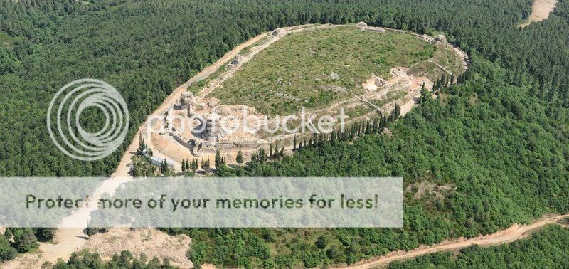
The construction date of Aydos Castle, located in Pendik at a height of 531 m from the sea, is unknown. This Byzantine castle was annexed in the Ottoman territory between 1327 and 1328 by Sultan Orhan I. The ellipse-shaped structure of the Castle that is 120 meters at its widest point and 50 meters in length, completely encloses the summit of the hill. The Castle dating from the Byzantine period is called by locals as Keçikale. It was conquered by Kara Abdurrahman Gazi in the period of Orhan Gazi, in 1328. The maintenance and repair of the castle is continuing. There is a cistern, whose dimensions are 12 x 7,5 m, within the walls.
AYDOS CASTLE EXCAVATIONS IN 2010
Excavation and workshop activities were conducted at the Aydos Castle located in the territories of the Kartal, Pendik, Sultanbeyli and Samandıra municipalities in the İstanbul Province under the supervision of our Museum between 13.09.2010 and 17.02.2011. The excavations were conducted in accordance of the Regional Board for the Conservation of Cultural and Natural Assets, issued to meet the requirements of the survey, restitution and restoration projects prepared by the Samandıra Municipality, and with the excavation and drilling permission of the General Directorate of Museums.
The castle is named after the hill called Mount Aydos, on which it is located. The name "Aydos" supposedly comes from "aetos", the Greek word for "eagle". The castle, which covers an area of 26,000 square meters beginning from its outer walls, is located on a 325-meters-high hill and overlooks the region in which it is located, like other castles. In terms of its plan, it is situated in the northeast-southwest direction in accordance with the topography, and it has an oval shape.
Apparently, the castle was built upon the bedrock, and during its construction, the top of the hill was partially flattened. In order to reinforce the defense, it has two different walls, namely the inner and outer walls. The inner defensive wall has six and the outer defensive wall has seven visible bastions. In accordance with the requirements of the restoration project, excavation activities were conducted on both sides of the inner wall, in and around the bastions adjacent to the wall, in the cisterns seen inside the castle and around the gates discovered during excavation activities, on water systems and on one grave.
During excavations conducted in this limited area, important architectural units of the castle and many movable cultural assets were unearthed. The main architectural units unearthed include the bastions adjacent to the inner wall, wall-walk stairs near the bastions, gates, water systems, cisterns, and loopholes.Bastions and wall-walk stairs: All bastions unearthed during excavations are made of local stones and have a semicircular form.
In the outer wall masonry of the inner bastion located southwest of the castle, a well-preserved waffle slab decorated with bricks was discovered. This waffle slab bears the architectural features of the 13th-14th centuries. This bastion appears as the most important bastion of the castle with its size and careful masonry. The eastern part of the castle overlooks a steep valley, and therefore, it is very difficult to climb to the castle using this direction. Thus, the defense needs were limited and there is only one bastion in this part.
During activities carried out around the inner bastion, the well-preserved wall-walk stairs made of local stones and mortar leading to the wall-walk (walkway allowing soldiers to move easily on the higher parts of defensive walls and to defend the castle) were found. Gates: During excavations conducted at the castle, three gates, located south, east and west of the inner wall were unearthed in total. The gate to the southeast was constructed fully as a gate and in a careful manner; there are traces of semicircular defensive towers on both sides of it.
It is known that castles have entrance gates protected by towers on their both sides. Thus, this was probably the main gate to the castle. Apparently, in a later period, the south of this arched gate was closed with stone filling, and it was added to the large bastion south of it. It is known that castle gates were sometimes closed during attacks; thus, this gate supposedly lost its function during or before an attack in order to construct a stronger tower, and it was added to the large bastion.
Furthermore, in the area east of the castle, where the beginning and end of the inner wall intersects, a floor the ground of which is made of Khorasan mortar and bricks, and a wide gate opening surrounded by a marble lintel and remains of columns were unearthed. This should be another important gate to the castle.
Small Finds: Most of the small finds unearthed during excavations consist of glazed and unglazed pottery and remains of pottery dating from the 13th-14th centuries. Other finds include coins dating from the 11th-14th centuries and remains of ceramic ware dating from the 11th-13th centuries. Almost no material dating from the Ottoman Empire was obtained (except a bowl dating from the 19th century).
Grave: During excavations, one grave was discovered southeast of the castle, next to the inner wall. The preliminary inspection by archaeologist-anthropologist Dr. Yasemin Yılmaz revealed that the skeleton belongs to a woman aged between 22 and 29.
Aydos Castle Legend: The Aydos Castle is renowned not only for its remains, but also for its legend mentioned in Ottoman sources. The main characters of this legend narrated in Tacü't Tevarih ("Crown of Histories"), regarded as one of the main sources of the foundation period of the Ottoman Period written by Hoca Sadeddin Efendi, are the daughter of the ruler (tekfur) of the Aydos Castle and Abdurrahman Gazi, a commander of Orhan I known as the conqueror of Aydos.
One night, the daughter of the ruler of the castle fell into a deep well in her dream, and she was rescued by a young man. The daughter of the ruler fell in love with her rescuer. When the castle was besieged by the Ottoman army, the daughter of the ruler, who saw the young man leading the army, recognized that he had been the young man in her dream. This commander leading the siege was Abdurrahman Gazi.
The daughter of the ruler sent a note to the man she loved, and asked him to prepare a withdrawal plan, so that she could let them into the city in the night. So, the Ottoman army moved away, like a retreating army. The people in the castle thought that the Ottoman soldiers had escaped. The commander of the Ottoman army, Abdurrahman Gazi, who returned in the night, was let into the city by the daughter of the ruler, the gates of the castle were opened, and Ottoman soldiers seized the castle.
Assessment
The Aydos Castle should have had an important position in the eastern border of the Byzantine Empire during the Late Byzantine Period, when its territory was shrinking. Between 1326 and 1328, Ottomans seized the present-day Kocaeli peninsula and some of the settlements in the Anatolian side. In that period, the Ottoman-Byzantine border was on the line between Aydos and Pendik. When it was constructed, the castle should have been on a secondary road towards the inner parts of the Kocaeli Peninsula connecting Constantinople to the east.
It is known that the Byzantine State, which had weakened militarily and politically in the 11th century and begun to lose land in Anatolia after the defeat of Manzikert (Malazgirt) in 1071, constituted a defensive network in the whole Anatolia against the Turks. In this period, most of the structures built by the Byzantine Empire in Anatolia were castles. It is thought that the first construction activities for the Aydos Castle also had been carried out in the same period, because of the small finds dating from the 11th-12th centuries.
Additionally, on the basis of current finds and our current knowledge, it can be said that the first phase of the castle had been realized in and around the southeastern gate protected by the towers on its both sides, namely the inner bastion. The outer covering system of the bastion that we call the "Başkale" ("Main Castle") suggests that it had been added in the 13th-14th centuries; in other words, that there had been a new construction activity in the 13th-14th centuries.
The traces on the same bastion reveal that the bastion underwent additions in three different periods. The lack of small finds dating from the Ottoman Period confirms the information provided by the publications of Ottoman historians who stated that the castle had been abandoned shortly after its seizure by the Ottomans. Architectural features and small finds indicate that the castle had reached its peak use period in the 13th and 14th centuries.
LOCATION SATELLITE MAP
WEB SITE :
Sultanbeyli Municipality
MORE INFO & CONTACT
E-Mail :
belediye@sultanbeyli.bel.tr
Phone : +90 216 564 1300
Fax : +90 216 398 4884
These scripts and photographs are registered under © Copyright 2015, respected writers and photographers from the internet. All Rights Reserved.


