Showing posts with label aqueduct. Show all posts

Sunday, December 25, 2016

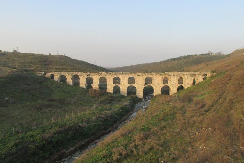
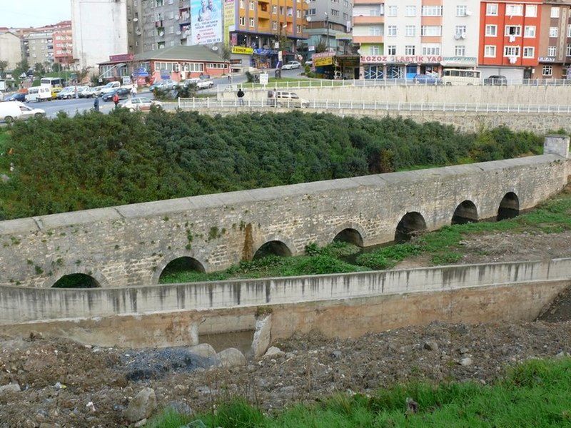
BALIKLI AQUEDUCT

Yunus Emre, Sultangazi - İstanbul - Turkey

GPS : 41°05'31.0"N 28°54'25.0"E / 41.091944, 28.906944

 photo balikli_aqueduct103.jpg

PHOTOGRAPHS ALBUM


The aqueduct is 125 metres long and 3 metres wide and 3.5 m in height. The aqueduct has 9 bays.

This aqueduct 4 km south of Cebeciköy is the largest of the aqueducts which were entirely rebuilt in the 15th century during the reign of Sultan Mehmed II on the Roman water line leading from Cebeciköy to Bozdoğan. It is named after an underground pool of water, Balıklı Havuz or Pool with Fish, dating from the late Roman period.

Pool is 12 m x 18.4 m and have 3 rooms.

LOCATION SATELLITE MAP


These scripts and photographs are registered under © Copyright 2016, respected writers and photographers from the internet. All Rights Reserved.

Saturday, December 24, 2016

GÖZLÜCE AQUEDUCT

Cebeci, Sultangazi - İstanbul - Turkey

GPS : 41°07'19.6"N 28°53'55.4"E / 41.122111, 28.898722

 photo gozluce_aqueduct105.jpg

PHOTOGRAPHS ALBUM

Gözlüce or the Güzelce Aqueduct is located on the Cebeci stream and is 5 km away from Başhavuz. The aqueduct was built of cut stone and there are eight arches on the first layer and eleven arches at second layer. These piece of art, also known as Cebeciköy Aqueduct, was contructed by Mimar Sinan during Kanuni Sultan Suleyman’s period, and lies 1500 m in east of the village of Cebeci, south of Kemerburgaz.

This is the Güzelce (also called Gözlüce or Cebeciköy) Aqueduct, one of the most significant aqueducts in the Kırkçeşme Water Works System.  The structure now remains in the Alibeyköy Dam Lake. There are two different routes that take us to the aqueduct, one leading to its east, the other to its west side.

The aqueduct built by Sinan which are perhaps the most significant ones among structures that deal with water systems. The aqueduct’s walls are 5.4 m thick at the bottom and 2.6 m thick at the highest point, at 29.5 m in height. The aqueduct is at 155 m length. Also known as the Cebeciköy Aqueduct, it resides within the Alibeyköy regional water collection basin.

Located far, in such a natural environment, in addition to its architectural quality, it has ensured preservation as well as its original design and construction characteristics; today, the Aqueduct still displays its 16th century monumentality. Parts of the lower section has recently been restored using cement-mix mortar.

This is one of the 33 aqueducts that take place within Kırkçeşme Water Supply System. The goal was to bring water from Belgrad Forest and Kemerburgaz to Eğrikapı cellar, over Eyüp. Güzelce Aqueduct, also known as Gözlüce Aqueduct was constructed by Architect Sinan during the period of Kanuni Sultan Süleyman the Magnificent, located 1500m east of Cebeci Village, near Kemerburgaz.

Incidental to the increase of population, Sultan Süleyman wanted to bring water from the north of the city, which is known as Belgrad Forests area, to fulfill the needs for water in the city. This aqueduct is also known as Cebeci Aqueduct, as it is located over the Cebeciköy River. As a result of inundation in 1563, Güzelce Aqueduct has been completely seperated from its foundation but did not collapse.

That is why the construction of the structure lasted 9 years. Güzelce Aqueduct, with its water supply system is an important example, indicating the great organization achievement; as it was built within a 9 years of period, which is considered to be a short time for that era in which many monuments were being erected.

The 16th century aqueduct of Sinan has been completely seperated from its foundation but did not collapse, as a result of an inundation in 1563, Güzelce Aqueduct. That is why the construction of the structure lasted 9 years.

Today, there is only a thin water flow, passing under the aqueduct. Structure is almost totally visible. The structure can be mentioned as a well preserved one, among Sinan's works of architecture. However, the lower levels of the aqueduct is lately repaired by concrete mortar.

Exit to TEM from the Kemerburgaz-Hasdal road, then take the Alibeyköy exit and drive towards Gazi Neighborhood.  Within a short while, you will drive through uneven dirt roads to two more 16th century aqueducts built by Sinan which are perhaps the most significant ones among structures that deal with water systems.

LOCATION SATELLITE MAP


These scripts and photographs are registered under © Copyright 2016, respected writers and photographers from the internet. All Rights Reserved.

AVASKÖY AQUEDUCT

Atışalanı, Esenler - İstanbul - Turkey

GPS : 41°03'04.9"N 28°53'00.7"E / 41.051361, 28.883528

 photo avaskoy_aqueduct102.jpg

PHOTOGRAPHS ALBUM

Avasköy Aqueduct (Karakemer, Tekkemer, Yılanlıkemer) situated in Atışalanı, with 11 arches and a single storey it is 10.3 m in height. The Avasköy aqueduct was built by Mimar Sinan. It is at 109.5 m in length and the opening of space at the middle arch is 6 m and at the others are 4.5 m.  The inner diameter of the water pipe drains of this aqueduct which had been built by using hard limestone are 21 cm.

This aqueduct is known as Avasköy Aqueduct or Yılanlıkemer in old maps and the water pipes of Süleymaniye and Beylik waters flows on this aqueduct. The aqueduct was constructed by Mimar Sinan. Avasköy Aqueduct is mentioned both in Tezkiret'ül-Bünyan and Tezkiret'ül-Enbiye among the aqueducts constructed by Mimar Sinan.

The elegance and applied technique in the structure of this aqueduct demonstrates that it is a structure of Mimar Sinan. Arch buttresses that Sinan had applied to Uzunkemer, Paşa Aqueduct and the other aqueducts in order to meet the horizontal forces has been applied to this aqueduct in the same way, too. These arch buttresses have asperities with width of 3 m. and base of 0,60-0,75 m and they are becoming zero at the top.

This aqueduct was drawn with 11 apertures in the map of Süleymaniye Waterways; it was drawn with 12 apertures in the map dated 1607 which is found in the Library of Ahmed III of the Topkapı Palace Museum and it was also drawn with 12 apertures in the map dated 1748.

Esenler, a residential area from the Byzantines. The most ancient people of this region were the Greek people who lived in the villages named Litros (Esenler) and Avas (Atışalanı). The Avas Esenler and Atışalanı villages were Istanbul's Byzantine villages during the magnificent period of time of Byzantine Empire until the conquest by the Turks in ancient times and contributed to Byzantine Empire by growing agricultural products.

LOCATION SATELLITE MAP


These scripts and photographs are registered under © Copyright 2016, respected writers and photographers from the internet. All Rights Reserved.

MAZULKEMER AQUEDUCT

Atışalanı, Esenler - İstanbul - Turkey

GPS : 41°04'15.5"N 28°51'04.3"E / 41.070972, 28.851194

 photo mazul_aqueduct104.jpg

PHOTOGRAPHS ALBUM

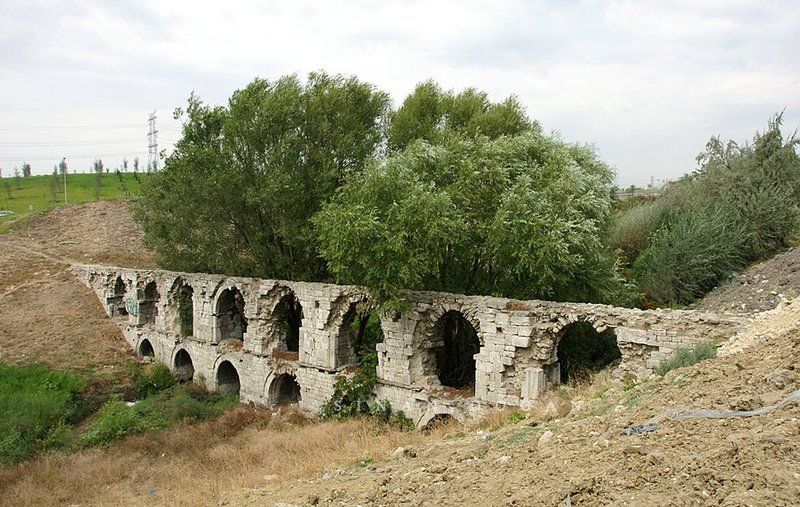
Mazulkemer Aqueduct (Kemerkece), located on Uzuncaova stream close to Esenler, Mazulkemer is within a restricted military zone. The name Mazulkemer means dismissed or suspended. The first water supply systems which were built in Istanbul date back to the foundation of the city. Two of the greatest aqueducts built in the Roman period are the Mazulkemer Aqueduct and the Valens Aqueduct.

These aqueducts were built in order to channel water from the Halkalı area in the western edge of the city to the Beyazıt district in the city center, which was known as the Forum Tauri in the Roman period. After reaching the city center, the water was later collected in the city's numerous cisterns, such as the famous Philoxenos (Binbirdirek) Cistern and the Basilica (Yerebatan) Cistern.

This aqueduct, which was built in the 4th century, underwent restoration in 741 - 775. An important part of the Süleymaniye Water Ways, the aqueduct was called the Beylik Water Way following its restoration in the reign of Sultan Mahmut I (1730 - 1754). The length of the aqueduct is 110 m, and there are thirteen arches above and seven arches (since two of them were broken, only five of the bottom ones can be seen.)

In addition to the Forest of Belgrade, to the north of the city, the rich aquiferous zone around Halkalı west of the city provided the main local sources of water (Çeçen 1991). The archaeology of water supply systems in both these areas is dominated by remains of the Ottoman supply systems that superceeded the Byzantine.

Extensive repairs to the Halkalı line immediately followed the conquest of the city by Sultan Mehmet II and more lines were gradually added. Some 17 individual channels dating to the Ottoman period are known to have emerged from the Halkali region to supply the city. However the commanding presence of the Mazulkemer, a massive two-tier water bridge perhaps alludes to a longer period of activity.

In form and composition the Mazulkemer appears to be different from other Ottoman aqueducts on the same line. For this reason it has been suggested that this aqueduct might originally have been built for the Roman system, that was supplemented in the 4th century by the long-distance line. Evidence of major rebuilding on this bridge suggest that it was active for a considerable period of time at at some point its arches required strengthening.

The bridge is now within the confines of a Military Zone, which has prevented closer study, but at the same time served to protect the monument.

LOCATION SATELLITE MAP


These scripts and photographs are registered under © Copyright 2016, respected writers and photographers from the internet. All Rights Reserved.

Saturday, December 17, 2016

ALİ PAŞA AQUEDUCT

Kemerburgaz, Eyüp - İstanbul - Turkey

GPS : 41°03'25.0"N 28°53'17.0"E / 41.056944, 28.888056

 photo alipasa_aqueduct108.jpg

PHOTOGRAPHS ALBUM

Ali Paşa Aqueduct (Şirinkemer), between Metris farm and the Avasköy aqueduct, was built between 1790 and 1791. The aqueduct has six bays below and eight at the top. It is at 66 m in length.

Ali Paşa Aqueduct is located on an affluent of the Ayvalı River four kilometres northwest of Istanbul city walls. Until recently the stone inscription giving the date of construction as 1205 AH (1790) was still legible, but the aqueduct has deteriorated considerably since then.

The architect is unknown. According to the Köprülü Map of 1859 this aqueduct was known as Şirinkemer

LOCATION SATELLITE MAP


These scripts and photographs are registered under © Copyright 2016, respected writers and photographers from the internet. All Rights Reserved.

Friday, December 16, 2016

MOĞLOVA AQUEDUCT

Kemerburgaz, Eyüp - İstanbul - Turkey

GPS : 41°08'10.0"N 28°53'35.0"E / 41.136111, 28.893056
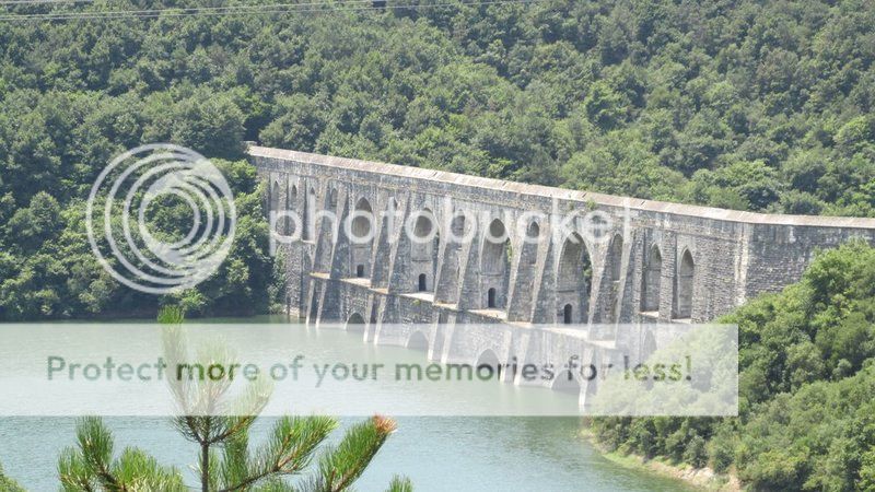
 photo maglova_aqueduct102.jpg

PHOTOGRAPHS ALBUM

The Moğlova Aqueduct, which was built on Ali Bey Stream, 4 km northeast of Kemerburgaz between 1554 and 1563. It is one of the most important parts of the Kırkçeşme Water Facility. The aqueduct, destroyed in a major flood following its completion in 1563, was rebuilt by Sinan the Architect at a cost of 9.791.044 coins. This is one of the 4 built in de Alibey river valley.

The Moğlova Aqueduct built by Mimar Sinan in Istanbul between 1554-1562 is with thirty three arches and 260 m in lengthfrom its base is 47.11 meters high, decked with two-storeyed arches. It also functioned as a pedestrian bridge, thanks to a passage running through the piers of the arches. The wall thickness at the upper floors is 3.05 m and at the ground floor is 4.5 m. The openings of the four major bays at the bottom are 16.75 m, the upper arches are 13.45 meters.

Sinan managed to blend the bearing and functional elements into a work of art. The first aqueduct was destroyed by violent floods (1563) so Sinan obviously went to greater lenghts in his second attempt. The reconstruction of the Maglova aqueduct in 1564 was even more expensive, over 50 million akçe. The Moğlova Aqueduct, a thing of exceptional strength and beauty that is sadly no longer accessible to casual visitors.

This structure is a masterpiece of Architect Sinan, which is also known as the unique and the most significant water heritage worldwide. Moğlova Aqueduct is mentioned to be the most beautiful piece of Kırkçeşme Water Supply System that provided water from Belgrad and Kemerburgaz to the city center's distrubition point, Eğrikapı.

This two-storeyed structure was not only used to carry water but also functioned as a pedestrian bridge, with a passage running over the lower arches. It forms part of the Kırkçeşme water system, which brought water to a distribution center known as Savaklar or Eğrikapı Maksemi just outside the old city walls. From here it was able to supply 158 different locations that included seven palaces, 94 public drinking fountains, 15 watering troughs, 19 wells, and 13 public baths.

Today's masterpiece is a result of a secondary construction of Architect Sinan, which was in progress after the total ruin of the first Moğlova Aqueduct by the 1563's inundation.The structure is also known as the Justinian Aqueduct, because Moğlova carries the remnants of Byzantine Age. The structure's uniquness as the following: Moğlova aqueduct eschews the vertical, two dimensional wall-like structure of tradition for a three dimensional system which is more stable against horizontal stress.

Its elegance and engineering datas are incomparable properties of the aqueduct. This sculpture like structure has unique piers' meeting the fender piles. Furthermore, the aqueduct is the highest one among Kırkçeşme Water Supply Sysem with 47.11 m of height. Alibeyköy Dum Lake's water has presently covered almost quarter of the structur.

However the drought of 2007 that took place in Turkey, occured as a result of very few rain, has caused the structure to be comprehended completely. Moğlova, still continues to carry water and has become a place of interest for fishers and childeren of the environment, especially during the weekends.

After the water transported from the eastern and western branches of the Kâğıthane Stream joins in Başhavuz (the Main pool), the main transfer gallery runs to the south. The water in the gallery here passes through the valley of Alibeyköy Stream over the Moğlova aqueduct. The prominent western authors, who attributed every significant building to the Byzantines also referred to these aqueducts as Justinyen aqueduct.

However, based on the research, the structure of the aqueduct and the information in his memories (Tezkirtü’l-Bünyan) that Sinan got written by his friend Nakkaş Sai Mustafa Çelebi (the calligrapher) few years before his death, it was proved that this aqueduct was definitely a work of Sinan.

Moğlova Aqueduct is 258 meters long and 35.30 meters high and is double-storied. Moğlova Aqueduct is a masterpiece in terms of both engineering and architecture and is unique in the world. Prof. Dr. Kazım Çeçen, who produced hundreds of valuable works and conducted many studies on this subject, acknowledged that “Even if Sinan had designed and built the Mağlova Aqueduct, he would still have won the same fame and known as a great engineer and architect”.

One of the downsides of Moğlova aqueduct is the fact that its location is out of the way; the other one is that the stirrup of its lower arch is 1 meter below the water level due to the Alibey Dam. The repair and maintenance carried out during the construction of the dam by the water administration of İstanbul was very successful, the rising water of the lake of dam has not had a negative effect and the Aqueduct is still intact despite being under the water.

LOCATION SATELLITE MAP


These scripts and photographs are registered under © Copyright 2016, respected writers and photographers from the internet. All Rights Reserved.
PAŞADERE AQUEDUCT

Kemerburgaz, Eyüp - İstanbul - Turkey

GPS : 41°10'08.8"N 28°56'13.7"E / 41.169111, 28.937139

 photo pasadere_aqueduct118.jpg

PHOTOGRAPHS ALBUM

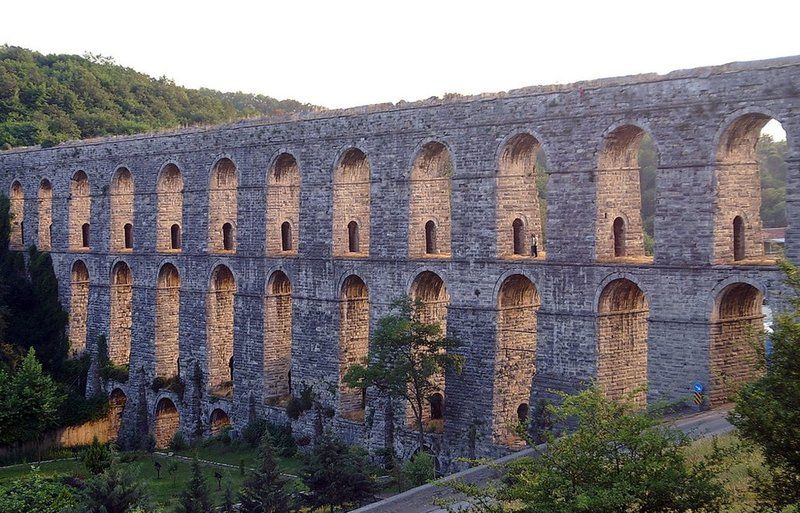
Paşadere (Evvelbent) Aqueduct between Bahçeköy and Kemerburgaz is one of the most important parts of Kırkçeşme Water Facility. Today it is in a rather good situation. It was built by Sinan the Architect in 1563 - 1564. The aqueduct, whose original name was Balıklızade, was later called Paşa because it takes water from the Paşa stream nearby. At 102 m in length, 16.4 meters in height the width of each of the aqueduct’s thirteen bays is 5 meters.

Because it was part of the Kırkçeşme Water Works system, it has been well preserved and remains intact today. Unfortunately, due to heavy foliage surrounding the area, especially during summer time, only a small portion of the Aqueduct is readily visible.

Follow the lush, green road that leads from Sarıyer Bahçeköy towards Kemerburgaz. The first aqueduct you will see that is Sinan’s work, is the Pashadere Aqueduct.  If you have set upon this journey during summer months, you will be able to view only a small portion of this structure through the greenery.  Passing underneath the aqueduct, the road will take you to the center of Kemerburgaz.

Driving on the asphalt road from Kemerburgaz, you can easily reach two other aqueducts : Uzun Aqueduct and Kovuk (Bent) Kemer. You can find the Kovuk Kemer by taking a left turn from central Kemerburgaz. It is on the Kemerburgaz-Hasdal road.

This is one of the 33 aqueducts that take place within Kırkçeşme Water Supply System. The goal was to bring water from Belgrad Forest and Kemerburgaz to Eğrikapı cellar, over Eyüp. Paşadere aqueduct, also known as Evvelbent was constructed by Architect Sinan during the period of Kanuni Sultan Süleyman the Magnificent.

The Kırkçeşme Water Supply System was divided into two branches on the water conveyance line. Paşadere Aqueduct is located on the eastern side of this organization. Incidental to the increase of population, Sultan Süleyman wanted to bring water from the north of the city, which is known as Belgrad Forests area, to fulfill the needs for water in the city.

As a fragment of Kırkçeşme Water System, the structure has survived in a good condition and well preserved up to now. However due to heavy foliage surrounding the area, especially during summer time, only a small portion of the Aqueduct is readily visible.

LOCATION SATELLITE MAP


These scripts and photographs are registered under © Copyright 2016, respected writers and photographers from the internet. All Rights Reserved.

KOVUK AQUEDUCT

Kemerburgaz, Eyüp - İstanbul - Turkey

GPS : 41°08'51.0"N 28°55'20.0"E / 41.147500, 28.922222

 photo kovuk_aqueduct104.jpg

PHOTOGRAPHS ALBUM

Kovuk Aqueduct built by Mimar Sinan in between 1554-1564, the whole first storey and some parts of the second storey of the Kovuk Aqueduct were built in Byzantine Period. It was built over the foundations of a previous Byzantine aqueduct.

The aqueduct, which is 2 km outside of Kemerburgaz centre, is located on the Kemerburgaz - Hasdal road. It is a three storied structure with a total length of 408 meters. The height of the Kovuk Aqueduct is approximately 35 meters. The wall thickness is around 7 meters at the first floor, it is 3.3 meters at the top floor.

One end of the aqueduct has been covered over by a factory that belongs to the Municipality and at the other end, there are beehives. You can climb the aqueduct and view the structure where it makes an almost ninety degree turn.

The bold but old and fatigued walls of the old aqueduct have been retired and water is now carried over to Istanbul by pipes laid down according to new technologies.

The aqueducthas been a fragment of the Kırkçeşme Water Supply System which was providing water supply between Bergrad and city center, over Eyüp district of İstanbul. This water supply was divided into two branches on the water conveyance line. Eğri Aqueduct is located on the eastern side of this organization.

It is also the biggest aqueduct among the eastern fragments.  It has acted an important role for water to pass over the Kağıthane Stream. It also provides access for pedestrians to walk over the aquedacts. However, a factory, latter built next to the aquedact entrance blocks to go through the structure.

Presently, the aqueduct is a well preserved structure, reflecting Sinan's architectural approach; however a factory that was built next to it blocks some of the structure to be viewed.

However, the pedestrian overpasses on the upper sections make it possible to view the aqueduct from a higher elevation. Furthermore there are ongoing surveys for the restoration of the aqueduct.

LOCATION SATELLITE MAP


These scripts and photographs are registered under © Copyright 2016, respected writers and photographers from the internet. All Rights Reserved.