Showing posts with label unkapani. Show all posts

Sunday, November 18, 2018

SAĞRICILAR (YAVUZ ER SİNAN) MOSQUE

Unkapanı, Fatih - İstanbul - Turkey

GPS : 41°01'17.6"N 28°57'43.8"E / 41.021556, 28.962167


PHOTOGRAPHS ALBUM

The mosque, which was built by Yavuz Er Sinan, banner bearer of Sultan Mehmet II, in 1455, is the oldest surviving mosque in İstanbul. It was restored in 1905 after the earthquake of 1894. However, it remained as a ruin for a long time after the fire of 1918. Renovated in 1960, the mosque measures 8.22 x 8.24 m. The fountain next to the mosque was restored in 1882.

When Horoz Dede, woke up soldiers by his imitating a rooster’s crow during the siege of Constantinople, passed away in the final assault, he was buried into the tomb behind the mosque, where Yavuz Er Sinan was also buried. In 1943, during construction works of Atatürk Boulevard, the tomb of Horoz Dede was moved next to Vakıf tombs.

The building is of the simplest type, a square room covered by a dome, the walls of stone. It was restored in 1960 with only moderate success. But although the mosque is of little interest architecturally, its historical background is rather fascinating. For one thing, this is probably the oldest mosque in the city, founded in 1455 by Yavuz Ersinan, standard-bearer in Fatih’s army during the final siege of Constantinople.

This gentleman was an ancestor of Evliya Çelebi; his family remained in possession of the mosque for centuries, living in a house just beside it. Evliya was born in this house in about 1611 and there, 20 years later, he had the dream which changed his life (and immeasurably enriched our knowledge of the life of old Stamboul).

The founder himself is buried in the little graveyard beside the mosque. Beside him is buried one of his comrades-in-arms, Horoz Dede, one of the fabulous folk-saints of Istanbul. Horoz Dede, or Grandfather Rooster, received his name during the siege of Constantinople, when he made his rounds each morning and woke the troops of Fatih’s army with his loud rooster call. Horoz Dede was killed in the final assault and after the city fell he was buried here, with Fatih himself among the mourners at his graveside. The saint’s grave is venerated to this day.

LOCATION SATELLITE MAP


These scripts and photographs are registered under © Copyright 2018, respected writers and photographers from the internet. All Rights Reserved.

Monday, May 29, 2017

HALİÇ METRO BRIDGE

Istanbul - Turkey

 photo metro_bridge117.jpg

PHOTOGRAPHS ALBUM

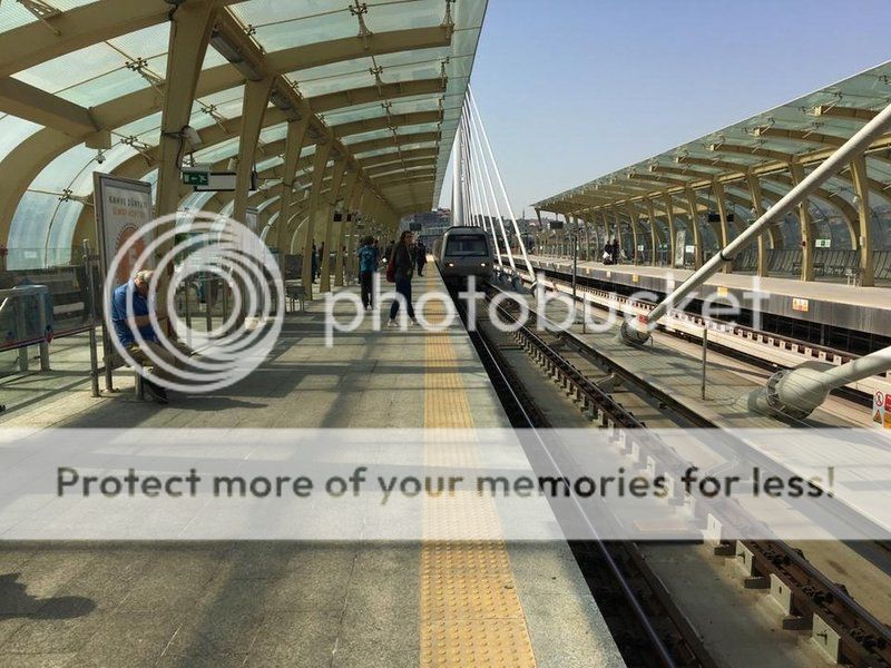
The Golden Horn Metro Bridge (Turkish: Haliç Metro Köprüsü) is a cable-stayed bridge along the M2 line of the Istanbul Metro, spanning the Golden Horn in Istanbul, Turkey. It connects the Beyoğlu and Fatih districts on the European side of Istanbul, and is located between the Galata Bridge and Atatürk Bridge, approximately 200 m (660 ft) east of the latter. It is the fourth bridge across the Golden Horn and entered service on February 15, 2014. The bridge enables a direct connection between the Hacıosman Metro Station in the Sarıyer district (at the northern end of the M2 line), with the Yenikapı transport hub in the Fatih district (at the southern end of the M2 line.)

The appearance of the bridge project in the general agenda goes back to 1952. After the approval of the metro line by the city's Monument Protection Board and the completion of the tunnels relating to the metro line, a construction bid for the metro bridge spanning the Golden Horn was published by the Metropolitan Municipality. By 2005, a total of 21 proposals were submitted to the Monument Protection Board; however, none were found to be sufficiently in harmony with the city's skyline.

A successful design, by architect Hakan Kıran, was controversial from the very beginning. In November 2009, the tower height was reduced from the initially projected 82 m (269 ft) to 65 m (213 ft) because the original height threatened the removal of Istanbul from the UNESCO list of World Heritage sites. The top level of cables was changed from 63 to 55 m (207 to 180 ft), and later in July 2011, it was further lowered to 47 m (154 ft). This revised design was approved in February 2012.

The bridge's conceptual design was carried out by French engineer and bridge specialist Michel Virlogeux, who also designed the Yavuz Sultan Selim Bridge (Third Bosphorus Bridge) currently under construction at the Bosphorus strait in Istanbul. Turkish architect Hakan Kıran was responsible for the architectural design and the construction supervision. Wiecon Consulting Engineers & Architects did the structural engineering work for the bridge.

It was built by a consortium of the Italian Astaldi SpA and the Turkish Gülermak Ağır Sanayi İnşaat ve Taahhüt A.Ş. Construction began on January 2, 2009, and was initially planned to be completed within 600 days. The construction time was extended, and the bridge was completed on January 9, 2013. Test runs of the metro line on the bridge began the next day, and the bridge went into service on 15 February 2014. Budgeted cost of the construction was €146.7 million.

Due to the historical character of the surroundings, the project underwent revisions relating to the alignment of the metro line. The discovery of a Byzantine-era vault on the Unkapanı bank during excavation works for pier foundations forced a redesign of the project. The design of the swing bridge operator's command building had to be revised when the wall of a Byzantine-era basilica and a graveyard on the same bank came to light.

The cable-stayed bridge has an overall length of 936 m (3,071 ft) between Azapkapı (Beyoğlu) and Unkapanı (Fatih), and a span of 460 m (1,510 ft) over water. The longest span between the two towers is 180 m (590 ft). It is flanked by viaducts at both sides, which connect the bridge with the metro tunnels on the opposite banks of the Golden Horn. Nine cables are connected to each side of the two towers in harp-design starting at a height of 47 m (154 ft).

To restrain the soft bedrock, dozens of steel pipe piles with diameters of 1,800 mm (71 in) and 2,500 mm (98 in), supplied from Europe, were driven using a hydraulic hammer more than 30 m (98 ft) deep into ground. The two steel supporting towers are 65 m (213 ft) high, Each resting on a nine-pile group while for the side supports four-pile or five-pile groups are built.

The 12.6 m (41 ft) wide bridge carries two metro railway tracks in the middle and a 4.4 m (14 ft) wide sidewalk in each direction at a height of 13 m (43 ft) above sea level. The deck is a 4.45 m (14.6 ft) high box girder.

On the Unkapanı side, a 120 m (390 ft) long swing bridge, essentially a cantilever structure, is to allow passage for large ships. It has 50 m (160 ft) and 70 m (230 ft) long spans, which rest on a central pier. Controlled from a room on a platform between the bridge and the shoreline, the swing bridge turns in right angle about the vertical axis after lifting, and provides about 40 m (130 ft) wide free clearance within four to six minutes.

It is planned that the swing bridge will be open once a week between the early hours of 1:00 and 5:00 in the summer time, and twice a week during these hours in the winter months. The gray color of the bridge was determined after extensive photographic studies of the surroundings.

A metro station with 180 m (590 ft) long platform, suitable for holding an 8-car train, is situated in the middle of the bridge. The station extends across the full length of the main span, and is capped with a 90 m (300 ft) long canopy. The color of the metro station on the bridge is light brown. It is expected that the metro line over the bridge will transport around one million passengers daily.

LOCATION SATELLITE MAP


These scripts and photographs are registered under © Copyright 2017, respected writers and photographers from the internet. All Rights Reserved.

Friday, May 26, 2017

UNKAPANI ATATÜRK BRIDGE

Unkapanı - Azapkapı, İstanbul - Turkey

 photo unkapani_bridge110.jpg

PHOTOGRAPHS ALBUM

Atatürk Bridge, alternatively known as the Unkapanı Bridge, is a highway bridge on the Golden Horn in Istanbul, Turkey. It is named after Mustafa Kemal Atatürk, the founder and first President of the Republic of Turkey.

It was originally completed in 1836 with the name Hayratiye Bridge, which connected the quarters of Unkapanı and Azapkapı. The construction of the Hayratiye Bridge was ordered by the Ottoman Sultan Mahmud II and supervised by Ahmed Fevzi Pasha, the Deputy Admiral of the Ottoman Fleet, at the Imperial Naval Arsenal (Tersane-i Amire) on the Golden Horn. The opening was personally made by Sultan Mahmud II in 1836, who crossed the bridge on his horse. This original bridge was circa 400 meters long and 10 meters wide, and was built as a bascule bridge for allowing large ships to pass.

The original name of the bridge, which was built on 3rd of September, 1836 over the Golden Horn, is Hayratiye (charity) because it was free of charge to use. The timber bridge, repaired between 1839 and 1840, was thought unsafe, and a new one was needed. When the bridge was charged for animals and carts for the construction of new a bridge, and the name was changed to Mahmudiye. The 504 m length bridge, built by French firm Forges and Chantiers de la Mediterranee in September 1872, was demolished in the storm of February 11, 1936.

In 1875 it was replaced by a second bridge, made of iron and constructed by a French company at the price of 135,000 Ottoman gold liras. It was 480 meters long and 18 meters wide, and remained in service between 1875 and 1912, when it was demolished due to reaching the end of its service life.

In 1912, the nearby Third Galata Bridge was disassembled in pieces and was re-erected at the site of the demolished Hayratiye Bridge, becoming the third bridge on this site. This bridge was used until 1936, when it was damaged by a storm.

The new bridge, designed by French Highways and Bridges Supervisor M. Pigeaud, opened for service on the 29th of October, 1939. The bridge is carried by 24 steel pontoons and is 477 m in length and 25 m in width. The current (fourth) bridge on this site was constructed between 1936 and 1940, and entered service in 1940 with the name Atatürk Bridge.

The Unkapanı Bridge, also known as Atatürk Bridge, was constructed in 1939 by a French firm. The bridges over the Golden Horn are still said to be the world's longest pontoon bridges. However, pontoons are considered to hinder the flow of water from the Golden Horn into the Sea of Marmara.

Historicly, on the site of the present Unkapanı Ataturk Bridge, there was a bridge called the “Jewish Bridge” (Yahudi Köprüsü) made of wooden planks. The purpose of building a bridge across the Golden Horn was to save citizens from paying a boat fee. For this reason, the bridge was known as the “Pious Deed  Bridge” (Hayrat Köprüsü). The name of the bridge was changed to “Atatürk Bridge” in 1935. Its wooden parquet floor was paved to asphalt in the repair in 1950.

LOCATION SATELLITE MAP


These scripts and photographs are registered under © Copyright 2017, respected writers and photographers from the internet. All Rights Reserved.