Showing posts with label buyukcekmece. Show all posts

Wednesday, September 4, 2019

CEMO KEBAP RESTAURANT

Kumburgaz, Büyükçekmece - İstanbul - Turkey

GPS : 41°01'41.1"N 28°27'38.7"E / 41.028078, 28.460751


PHOTOGRAPHS ALBUM

M E N U

SOUPS
Ezogelin : Kırmızı mercimek, pirinç, bulgur, pulbiber, nane
Mercimek : Sarı mercimek, soğan

DÖNERS
Porsiyon Döner
Pilav Üstü Döner
İskender
Tombik Döner

LAHMACUNS
Lahmacun
Kaşarlı Lahmacun
Fındık Lahmacun

KEBABPS
Kuzu Şiş
Adana Kebap (Acılı)
Urfa Kebap (Acısız)
Domatesli Kebap
Patlıcanlı Kebap
Yoğurtlu Kebap
İskender Kebap
Beyti Kebap (Sarma)
Izgara Köfte
Tavuk Şiş
Tavuk Kanat
Karışık Izgara
Güveç
Şiş Dürüm
Adana Dürüm (Acılı)
Urfa Dürüm (Acısız)
Tavuk Dürüm

PITAS
Kuşbaşılı Pide
Kıymalı Pide
Kaşarlı Pide
Sucuklu Pide
Karışık Pide
Kavurmalı Pide
Karadeniz Kapalı Pide

SALADS
Çoban Salata
Ezme Salata

DESSERTS
Antep Katmeri (Küçük)
Künefe

LOCATION SATELLITE MAP


WEB SITE : Cemo Kebap Restaurant

MORE INFO & CONTACT
E-Mail : info@cemokebap.com
Phone : +90 212 885 7483 / +90 212 885 4573
Mobile : +90 507 787 3402

These scripts and photographs are registered under © Copyright 2019, respected writers and photographers from the internet. All Rights Reserved.

Monday, May 29, 2017

SULTAN SÜLEYMAN BRIDGE

Büyükçekmece - Istanbul - Turkey

 photo bcekmece_bridge103.jpg

PHOTOGRAPHS ALBUM

This bridge is on the Büyükçekmece Lake, Kültürpark about 40 km from Istanbul, at the juncture of Büyükçekmece lake and Marmara Sea on the Istanbul-Edirne road. The bridge connects Büyükçekmece to the Mimarsinan Township.

Spanning 636 meters over the natural channel that connects the Büyükçekmece Lake with the Sea of Marmara to the south, the bridge was built beginning 1563 by Süleyman I (Kanuni Sultan Süleyman or Süleyman the Magnificent, 1520-1566) during his Szigetvar campaign. Upon his death, Selim II ordered the completion of the bridge and it was subsequently used during the return of the Army from the Expedition.

Sinan describes this bridge as one of his most favorite works. Perhaps this explains why the Büyükçekmece Bridge is the only one of his works that carries Sinan’s personal signature. Unfortunately, the original signature was stolen and has been substituted by a replica.

A stone bridge built by the Romans and restored by Mehmed II allowed passage further north prior to the construction of the current bridge by head-architect Sinan. Sinan also designed a small complex on the eastern bank of the channel for Sokullu Mehmed Paşa that consists of a fountain (çeşme), caravanserai (kervansaray) and a small mosque (mescit) known as Sokullu Mehmed Paşa Mescidi or Köprübaşı (foot of the bridge) Mosque. The bridge and the complex were completed a year into the rule of Sultan Süleyman's successor, Sultan Selim II (1566-1574).

The structure also known as the Büyükçekmece Bridge consists of four sections that individually ascend and descend carried on arches, resting on artificial islands placed in between. From east to west, the first two sections have seven arches each, followed by a five and a nine-arched section, with four-centered arches varying from 4.5 to 11.9 meters in width.

After choosing firm ground closer to the seabed to span the channel, Sinan laid hexagonal artificial islands with thick retaining walls for during low tide. Lead was poured into caissons dug into the seabed prior to filling the foundations to create a stronger foundation.

The bridge carries a two-lane cobblestone road that is protected with shallow stone barriers on either side. The first section at the eastern end has two stone balconies at its apex that project over the river carried on stone braces. The forth section, to the west, has two inscription panels facing each other on either side of the road. Composed in Arabic, the southern panel offers praise to Süleyman I and Selim II and gives the date of construction.

Mimar Sinan, who is referred to as Yusuf bin Abdullah in this panel, also has a signature to its side displaying this alternative name that is only mentioned in an early version of his monograph, Tezkiret-ül Ebniye. The northern panel is in Turkish and announces the completion of the bridge by Sultan Selim II.

A highway bridge was built to the south of the Sultan Süleyman Bridge in 1950 to accommodate intercity traffic. The historic bridge was restored in 1970 by the Turkish Highways Administration and is closed to traffic.

LOCATION SATELLITE MAP


These scripts and photographs are registered under © Copyright 2017, respected writers and photographers from the internet. All Rights Reserved.

Friday, January 13, 2017

BÜYÜKÇEKMECE LAKE

Küçükçekmece - Istanbul - Turkey

GPS : 41°05'20.0"N 28°31'10.4"E / 41.088898, 28.519551

Buyukcekmece Lake / Catalca - Istanbul photo bcekmece910.jpg

PHOTOGRAPHS ALBUM

Lake Büyükçekmece (Turkish: Büyükçekmece Gölü) is a liman formed at the point where the river Karasudere flows into the Marmara Sea. The lake is located south of the Çatalca district, west of Istanbul, Turkey. It is used as a freshwater reservoir.

The lake's bar was reinforced in 1988 by a dam. The area of the lake is 28.47 km2 (10.99 sq mi), and is 7 km (4.3 mi) long and 2 km (1.2 mi) wide. The maximum depth is 8.6 m (28 ft), following deepening carried out by the State Hydraulic Works.

The fluvial lake developed as the flow of Karasudere, and as it came downwards from Çatalca it was blocked off and formed by the resulting sandbank it created. A reedy, brackish salt-water lake exists between the Büyükçekmece Dam and the Marmara Sea. Another lagoon, Lake Küçükçekmece, is located around 12 km (7.5 mi) east of Lake Büyükçekmece.

The number of fish species observed in the lake has decreased from 30 in the past to 15 currently.

A historic 635 m (2,083 ft) long and 7.17 m (23.5 ft) wide multiple arch bridge, named after the Ottoman architect Mimar Sinan (1489-1588), spans the narrow opening at the bar connecting the lake to the sea.

At the northern shore of the lake, Istanbul Hezarfen Airfield is situated on a peninsula.

Primary inflows : Karasudere
Catchment area : 622 km2 (240 sq mi)
Max. length : 7 km (4.3 mi)
Max. width : 2 km (1.2 mi)
Surface area : 28.47 km2 (10.99 sq mi)
Max. depth : 8.6 m (28 ft)
Water volume : 16,161 hm3 (3.877 cu mi)

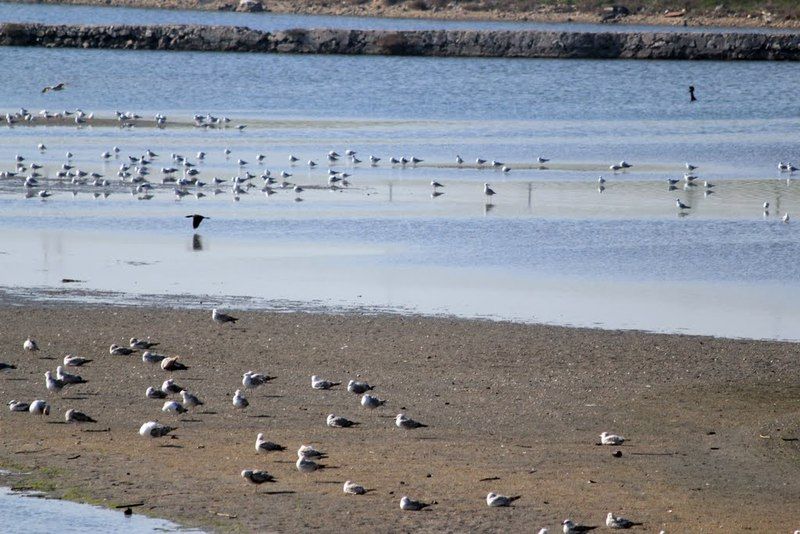
The lake, which is not protected, was declared by Bird Life International as an Important Bird Area in 1989 for its numerous distinct and threatened waterfowl species.

Among the breeding birds are Small Honeysuckle, Spinach, Elm, Oak, Hare, Long lLg, Marsh Falcon, Mallard, Little Grebe, Great Crested Grebe, Greater Flamingo, Grey Heron, Little Egret, Pygmy Cormorant, Great Cormorant, Eurasian Coot, Black-headed Gull, Mediterranean Gull, Yellow-legged Gull, Sandwich Tern, Common Tern, Rock Dove, Eurasian Collared Dove, Alpine Swift, Common Swift, Common Kingfisher, Eurasian Magpie, Western Jackdaw, Hooded Crow, Great Tit, Barn Swallow, Common Starling, House Sparrow, Western Yellow Wagtail, White Wagtail, Common Chaffinch.

LOCATION SATELLITE MAP


These scripts and photographs are registered under © Copyright 2017, respected writers and photographers from the internet. All Rights Reserved.